|
0 members (),
1,238
guests, and
22
robots. |
|
Key:
Admin,
Global Mod,
Mod
|
|
S |
M |
T |
W |
T |
F |
S |
|
|
1
|
2
|
3
|
4
|
5
|
6
|
|
7
|
8
|
9
|
10
|
11
|
12
|
13
|
|
14
|
15
|
16
|
17
|
18
|
19
|
20
|
|
21
|
22
|
23
|
24
|
25
|
26
|
27
|
|
28
|
29
|
30
|
|
|
|
|
|
There are no members with birthdays on this day. |

Volcano earthquake report for Friday, 5 Jun 2026
• Small magnitude 3.1 earthquake 11 miles southwest of Pukatja, South Austral...
• Moderate mag. 4.2 earthquake - 40 km west of Matias Romero Avendano, Estado...
• World Earthquake Report for Friday, 5 June 2026
• Magnitude 3.8 earthquake strikes near Carlsbad, Eddy County, New Mexico, US...
• Moderate mag. 4.7 earthquake - North Pacific Ocean, 244 km southeast of Hac...
|
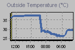
 Wednesday: Thundery Showers, Minimum Temperature: 8°C (47°F) Maximum Temperature: 15°C (59°F)
Webmaster
3 hours ago
Wednesday: Thundery Showers, Minimum Temperature: 8°C (47°F) Maximum Temperature: 15°C (59°F)
Webmaster
3 hours ago
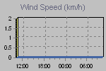
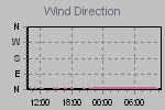
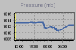
Maximum Temperature: 15°C (59°F), Minimum Temperature: 8°C (47°F), Wind Direction: westerly, Wind Speed: 9mph, Visibility: Moderate, Pressure: 1014mb, Humidity: 74%, UV Risk: 3, Pollution: Low, Sunrise: 04:41 BST, Sunset: 21:37 BST Source: Wednesday: Thundery Showers, Minimum Temperature: 8°C (47°F) Maximum Temperature: 15°C (59°F)
0
11
Read More
|
Tuesday: Light Rain Showers, Minimum Temperature: 8°C (47°F) Maximum Temperature: 15°C (59°F)
Webmaster
3 hours ago
Maximum Temperature: 15°C (59°F), Minimum Temperature: 8°C (47°F), Wind Direction: westerly, Wind Speed: 12mph, Visibility: Good, Pressure: 1011mb, Humidity: 67%, UV Risk: 4, Pollution: Low, Sunrise: 04:41 BST, Sunset: 21:36 BST Source: Tuesday: Light Rain Showers, Minimum Temperature: 8°C (47°F) Maximum Temperature: 15°C (59°F)
0
11
Read More
|
Tropical Storm Boris Forecast Discussion Number 8
Webmaster
4 hours ago
Issued at 900 PM CST Mon Jun 08 2026 649
WTPZ42 KNHC 090242
TCDEP2
Tropical Storm Boris Discussion Number 8
NWS National Hurricane Center Miami FL EP022026
900 PM CST Mon Jun 08 2026
Boris is meandering off the southern coast of Mexico this evening
after continuing on a northeasterly motion today, and is finally
making a slow turn toward the north. The storm is being impacted by
significant easterly wind shear, and the overall convective
structure has waned, as exhibited by warming cloud tops and lack of
organized banding features. However, objective and subjective
Dvorak intensity estimates range from 35-43 kt, so the initial
intensity is maintained at 40 kt.
The center of Boris was repositioned at 00z to the northeast of
the previously estimated track, based on geostationary and
microwave satellite data. Little change in intensity is expected up
until landfall. A gradual turn toward the northwest is expected
overnight into Tuesday as a mid-level ridge builds over the western
Gulf of America. Once inland, rapid weakening is forecast, and Boris
is expected to dissipate over the mountainous terrain of Mexico by
midweek. The official forecast track lies between the simple and
corrected dynamical model consensus but leans toward the latter
solution.
The threat of very heavy rainfall continues to be the primary hazard
of concern with this slow-moving system, which will likely result in
flash flooding and mudslides in mountainous terrain.
Key Messages:
1. Heavy rainfall associated with Tropical Storm Boris will impact
portions of southern Mexico. This rainfall will likely produce
life-threatening flooding and mudslides, especially in areas of
steep terrain.
2. Tropical storm conditions are likely occurring along the
coast within the Tropical Storm Warning area and will continue into
early Tuesday.
FORECAST POSITIONS AND MAX WINDS
INIT 09/0300Z 16.0N 98.3W 40 KT 45 MPH
12H 09/1200Z 16.6N 98.7W 30 KT 35 MPH...INLAND
24H 10/0000Z 17.5N 99.8W 25 KT 30 MPH...POST-TROP/INLAND
36H 10/1200Z...DISSIPATED
$$
Forecaster Adams/Papin Source: Tropical Storm Boris Forecast Discussion Number 8
0
15
Read More
|
Tropical Storm Cristina Forecast Discussion Number 4
Webmaster
4 hours ago
Issued at 900 PM CST Mon Jun 08 2026 584
WTPZ43 KNHC 090234
TCDEP3
Tropical Storm Cristina Discussion Number 4
NWS National Hurricane Center Miami FL EP032026
900 PM CST Mon Jun 08 2026
Another burst of deep convection has formed near and to the south of
Cristina, obscuring the low-level circulation that was evident
earlier, though the tropical storm continues to battle significant
northerly vertical wind shear. There has not been much change to
the subjective or objective intensity estimates, ranging from 31-43
kt, and the initial intensity for this advisory is held at 40 kt.
After moving northward earlier today, fixes from geostationary and
microwave imagery indicate that Cristina has slowed down
substantially, and its current estimated motion is 360/2 kt. The
track forecast continues to present a conundrum. Cristina moved
closer to the coast than anticipated earlier today, likely due to
its exposed center moving along with the strong monsoonal low-level
flow. With deep convection forming over the center this evening, it
has slowed its forward progression, and much of the track guidance
shows very little short-term motion. Thereafter, a mid-level ridge
remains located north of Cristina and may help to impart a slow
northwestward motion. However, the track guidance is not in good
agreement, with the Google DeepMind and GFS showing a southward
component of motion, while the ECMWF and HAFS-A/B show northward
solutions that quickly move Cristina inland over Central America.
The NHC track forecast leans toward these latter solutions, showing
a very slow motion over the next day or so, but eventually bringing
Cristina inland along the coastline of El Salvador between 36-48
hours. Given the spread in model solutions, this is a low confidence
track forecast.
Cristina is not very well organized due to the storm dealing with
35-40 kt of northerly vertical wind shear as diagnosed by SHIPS
guidance. While this shear is expected to gradually decrease over
the next couple of days, proximity to land, especially the high
mountains of Central America, could also keep Cristina's intensity
in check. The majority of the intensity guidance shows little
intensification, and the latest NHC intensity forecast now only has
Cristina maintaining its intensity while it remains just offshore.
If Cristina is able to move further away from the coast over warm
sea-surface temperatures and a moist environment, some
intensification remains possible, as suggested by the GFS model.
Assuming Cristina moves inland beyond 48 hours, rapid weakening is
anticipated with dissipation over Central America toward the latter
part of this week.
Key Messages:
1. Heavy rainfall associated with Tropical Storm Cristina will
impact coastal portions of Central America through Thursday. This
rainfall may produce life-threatening flooding and mudslides,
especially in areas of steep terrain.
2. Tropical storm conditions are expected to reach the coast of
Nicaragua, El Salvador, and Honduras overnight into Tuesday.
FORECAST POSITIONS AND MAX WINDS
INIT 09/0300Z 12.5N 87.8W 40 KT 45 MPH
12H 09/1200Z 12.5N 87.8W 40 KT 45 MPH
24H 10/0000Z 12.7N 87.9W 40 KT 45 MPH
36H 10/1200Z 13.0N 88.5W 40 KT 45 MPH
48H 11/0000Z 13.7N 89.7W 30 KT 35 MPH...INLAND
60H 11/1200Z 14.6N 90.4W 25 KT 30 MPH...POST-TROP/INLAND
72H 12/0000Z...DISSIPATED
$$
Forecaster Papin Source: Tropical Storm Cristina Forecast Discussion Number 4
0
16
Read More
|
Tropical Storm Boris Wind Speed Probabilities Number 8
Webmaster
4 hours ago
Issued at 0300 UTC TUE JUN 09 2026 000
FOPZ12 KNHC 090234
PWSEP2
TROPICAL STORM BORIS WIND SPEED PROBABILITIES NUMBER 8
NWS NATIONAL HURRICANE CENTER MIAMI FL EP022026
0300 UTC TUE JUN 09 2026
AT 0300Z THE CENTER OF TROPICAL STORM BORIS WAS LOCATED NEAR
LATITUDE 16.0 NORTH...LONGITUDE 98.3 WEST WITH MAXIMUM SUSTAINED
WINDS NEAR 40 KTS...45 MPH...75 KM/H.
Z INDICATES COORDINATED UNIVERSAL TIME (GREENWICH)
PACIFIC DAYLIGHT TIME (PDT)...SUBTRACT 7 HOURS FROM Z TIME
HAWAIIAN STANDARD TIME (HST)...SUBTRACT 10 HOURS FROM Z TIME
WIND SPEED PROBABILITY TABLE FOR SPECIFIC LOCATIONS
CHANCES OF SUSTAINED (1-MINUTE AVERAGE) WIND SPEEDS OF AT LEAST
...34 KT (39 MPH... 63 KM/H)...
...50 KT (58 MPH... 93 KM/H)...
...64 KT (74 MPH...119 KM/H)...
FOR LOCATIONS AND TIME PERIODS DURING THE NEXT 5 DAYS
PROBABILITIES FOR LOCATIONS ARE GIVEN AS OP(CP) WHERE
OP IS THE PROBABILITY OF THE EVENT BEGINNING DURING
AN INDIVIDUAL TIME PERIOD (ONSET PROBABILITY)
(CP) IS THE PROBABILITY OF THE EVENT OCCURRING BETWEEN
00Z TUE AND THE FORECAST HOUR (CUMULATIVE PROBABILITY)
PROBABILITIES ARE GIVEN IN PERCENT
X INDICATES PROBABILITIES LESS THAN 1 PERCENT
PROBABILITIES FOR 34 KT AND 50 KT ARE SHOWN AT A GIVEN LOCATION WHEN
THE 5-DAY CUMULATIVE PROBABILITY IS AT LEAST 3 PERCENT.
PROBABILITIES FOR 34...50...64 KT SHOWN WHEN THE 5-DAY
64-KT CUMULATIVE PROBABILITY IS AT LEAST 1 PERCENT.
- - - - WIND SPEED PROBABILITIES FOR SELECTED LOCATIONS - - - -
FROM FROM FROM FROM FROM FROM FROM
TIME 00Z TUE 12Z TUE 00Z WED 12Z WED 00Z THU 00Z FRI 00Z SAT
PERIODS TO TO TO TO TO TO TO
12Z TUE 00Z WED 12Z WED 00Z THU 00Z FRI 00Z SAT 00Z SUN
FORECAST HOUR (12) (24) (36) (48) (72) (96) (120)
- - - - - - - - - - - - - - - - - - - - - - - - - - - - - - - - - -
LOCATION KT
ACAPULCO 34 X 7( 7) X( 7) X( 7) X( 7) X( 7) X( 7)
P MALDONADO 34 81 1(82) X(82) X(82) X(82) X(82) X(82)
$$
FORECASTER ADAMS/PAPIN Source: Tropical Storm Boris Wind Speed Probabilities Number 8
0
15
Read More
|
Tropical Storm Cristina Wind Speed Probabilities Number 4
Webmaster
4 hours ago
Issued at 0300 UTC TUE JUN 09 2026 000
FOPZ13 KNHC 090233
PWSEP3
TROPICAL STORM CRISTINA WIND SPEED PROBABILITIES NUMBER 4
NWS NATIONAL HURRICANE CENTER MIAMI FL EP032026
0300 UTC TUE JUN 09 2026
AT 0300Z THE CENTER OF TROPICAL STORM CRISTINA WAS LOCATED NEAR
LATITUDE 12.5 NORTH...LONGITUDE 87.8 WEST WITH MAXIMUM SUSTAINED
WINDS NEAR 40 KTS...45 MPH...75 KM/H.
Z INDICATES COORDINATED UNIVERSAL TIME (GREENWICH)
PACIFIC DAYLIGHT TIME (PDT)...SUBTRACT 7 HOURS FROM Z TIME
HAWAIIAN STANDARD TIME (HST)...SUBTRACT 10 HOURS FROM Z TIME
WIND SPEED PROBABILITY TABLE FOR SPECIFIC LOCATIONS
CHANCES OF SUSTAINED (1-MINUTE AVERAGE) WIND SPEEDS OF AT LEAST
...34 KT (39 MPH... 63 KM/H)...
...50 KT (58 MPH... 93 KM/H)...
...64 KT (74 MPH...119 KM/H)...
FOR LOCATIONS AND TIME PERIODS DURING THE NEXT 5 DAYS
PROBABILITIES FOR LOCATIONS ARE GIVEN AS OP(CP) WHERE
OP IS THE PROBABILITY OF THE EVENT BEGINNING DURING
AN INDIVIDUAL TIME PERIOD (ONSET PROBABILITY)
(CP) IS THE PROBABILITY OF THE EVENT OCCURRING BETWEEN
00Z TUE AND THE FORECAST HOUR (CUMULATIVE PROBABILITY)
PROBABILITIES ARE GIVEN IN PERCENT
X INDICATES PROBABILITIES LESS THAN 1 PERCENT
PROBABILITIES FOR 34 KT AND 50 KT ARE SHOWN AT A GIVEN LOCATION WHEN
THE 5-DAY CUMULATIVE PROBABILITY IS AT LEAST 3 PERCENT.
PROBABILITIES FOR 34...50...64 KT SHOWN WHEN THE 5-DAY
64-KT CUMULATIVE PROBABILITY IS AT LEAST 1 PERCENT.
- - - - WIND SPEED PROBABILITIES FOR SELECTED LOCATIONS - - - -
FROM FROM FROM FROM FROM FROM FROM
TIME 00Z TUE 12Z TUE 00Z WED 12Z WED 00Z THU 00Z FRI 00Z SAT
PERIODS TO TO TO TO TO TO TO
12Z TUE 00Z WED 12Z WED 00Z THU 00Z FRI 00Z SAT 00Z SUN
FORECAST HOUR (12) (24) (36) (48) (72) (96) (120)
- - - - - - - - - - - - - - - - - - - - - - - - - - - - - - - - - -
LOCATION KT
P SAN JOSE 34 X X( X) 1( 1) 3( 4) 1( 5) X( 5) X( 5)
SAN SALVADOR 34 X X( X) 2( 2) 3( 5) X( 5) X( 5) X( 5)
PUERTO CUTUCO 34 12 7(19) 3(22) X(22) X(22) X(22) X(22)
AMAPALA 34 12 7(19) 2(21) X(21) X(21) X(21) X(21)
CHOLUTECA 34 5 2( 7) X( 7) 1( 8) X( 8) X( 8) X( 8)
$$
FORECASTER PAPIN Source: Tropical Storm Cristina Wind Speed Probabilities Number 4
0
15
Read More
|
Tropical Storm Boris Public Advisory Number 8
Webmaster
4 hours ago
Issued at 900 PM CST Mon Jun 08 2026 000
WTPZ32 KNHC 090233
TCPEP2
BULLETIN
Tropical Storm Boris Advisory Number 8
NWS National Hurricane Center Miami FL EP022026
900 PM CST Mon Jun 08 2026
...BORIS CLOSING IN ON THE SOUTHERN MEXICAN COASTLINE...
...LIKELY TO PRODUCE LIFE-THREATENING FLASH FLOODING THROUGH
TUESDAY...
SUMMARY OF 900 PM CST...0300 UTC...INFORMATION
----------------------------------------------
LOCATION...16.0N 98.3W
ABOUT 125 MI...200 KM ESE OF ACAPULCO MEXICO
ABOUT 30 MI...45 KM SE OF PUNTA MALDONADO MEXICO
MAXIMUM SUSTAINED WINDS...45 MPH...75 KM/H
PRESENT MOVEMENT...N OR 360 DEGREES AT 2 MPH...4 KM/H
MINIMUM CENTRAL PRESSURE...1001 MB...29.56 INCHES
WATCHES AND WARNINGS
--------------------
CHANGES WITH THIS ADVISORY:
None.
SUMMARY OF WATCHES AND WARNINGS IN EFFECT:
A Tropical Storm Warning is in effect for...
* Laguna de Chacahua to Tecpan de Galeana
A Tropical Storm Warning means that tropical storm conditions are
expected somewhere within the warning area, in this case over the
next 12 hours.
For storm information specific to your area, please monitor
products issued by your national meteorological service.
DISCUSSION AND OUTLOOK
----------------------
At 900 PM CST (0300 UTC), the center of Tropical Storm Boris was
located near latitude 16.0 North, longitude 98.3 West. Boris is
moving toward the north near 2 mph (4 km/h), and a turn toward the
northwest and an increase in forward speed is expected overnight. On
the forecast track, the center of Boris should reach the coast of
Oaxaca and Guerrero, Mexico, late tonight into Tuesday morning.
Maximum sustained winds are near 45 mph (75 km/h) with higher gusts.
Little change in strength is forecast until landfall. Rapid
weakening will occur after the center crosses the coast of southern
Mexico.
Tropical-storm-force winds extend outward up to 60 miles (95 km)
from the center.
The estimated minimum central pressure is 1001 mb (29.56 inches).
HAZARDS AFFECTING LAND
----------------------
Key messages for Boris can be found in the Tropical Cyclone
Discussion under AWIPS header MIATCDEP2 and WMO header WTPZ42 KNHC.
RAINFALL: Boris is expected to produce additional rainfall totals of
3 to 6 inches, with maximum totals of 8 inches possible across
coastal portions of the Mexican states of Guerrero and Oaxaca
through Tuesday. This rainfall may produce life-threatening flooding
and mudslides, especially in areas of steep terrain.
For a complete depiction of forecast rainfall associated with
Tropical Storm Boris, please see the National Weather Service Storm
Total Rainfall Graphic available at
hurricanes.gov/graphics_ep2.shtml?rainqpf
WIND: Tropical storm conditions are likely occurring along the
coast in the warning area and will continue into early Tuesday.
NEXT ADVISORY
-------------
Next intermediate advisory at 1200 AM CST.
Next complete advisory at 300 AM CST.
$$
Forecaster Adams/Papin Source: Tropical Storm Boris Public Advisory Number 8
0
7
Read More
|
Tropical Storm Cristina Public Advisory Number 4
Webmaster
4 hours ago
Issued at 900 PM CST Mon Jun 08 2026 000
WTPZ33 KNHC 090233
TCPEP3
BULLETIN
Tropical Storm Cristina Advisory Number 4
NWS National Hurricane Center Miami FL EP032026
900 PM CST Mon Jun 08 2026
...CRISTINA SLOWS TO A CRAWL JUST OFF THE COAST OF CENTRAL
AMERICA...
...HEAVY RAINFALL EXPECTED OVER THE NEXT FEW DAYS WITH COASTAL
FLOODING POSSIBLE IN AREAS OF ONSHORE WINDS...
SUMMARY OF 900 PM CST...0300 UTC...INFORMATION
----------------------------------------------
LOCATION...12.5N 87.8W
ABOUT 105 MI...170 KM WNW OF MANAGUA NICARAGUA
ABOUT 125 MI...200 KM SE OF SAN SALVADOR EL SALVADOR
MAXIMUM SUSTAINED WINDS...45 MPH...75 KM/H
PRESENT MOVEMENT...N OR 360 DEGREES AT 2 MPH...4 KM/H
MINIMUM CENTRAL PRESSURE...1004 MB...29.65 INCHES
WATCHES AND WARNINGS
--------------------
CHANGES WITH THIS ADVISORY:
None.
SUMMARY OF WATCHES AND WARNINGS IN EFFECT:
A Tropical Storm Warning is in effect for...
* Puerto Sandino to the Guatemala/El Salvador border
A Tropical Storm Warning means that tropical storm conditions are
expected somewhere within the warning area, in this case in the next
12 to 24 hours.
For storm information specific to your area, please monitor
products issued by your national meteorological service.
DISCUSSION AND OUTLOOK
----------------------
At 900 PM CST (0300 UTC), the center of Tropical Storm Cristina was
located near latitude 12.5 North, longitude 87.8 West. Cristina is
moving slowly toward the north near 2 mph (4 km/h), and a slow
meandering motion is forecast for the next day or so followed by a
slow northwestward motion. On the forecast track, Cristina should
move near or along the coast of Nicaragua, Honduras and El Salvador
over the next couple of days.
Maximum sustained winds are near 45 mph (75 km/h) with higher gusts.
Little change is strength is forecast over the next day or two.
Tropical-storm-force winds extend outward up to 70 miles (110 km)
from the center.
The estimated minimum central pressure is 1004 mb (29.65 inches).
HAZARDS AFFECTING LAND
----------------------
Key messages for Cristina can be found in the Tropical Cyclone
Discussion under AWIPS header MIATCDEP3 and WMO header WTPZ43 KNHC.
RAINFALL: Cristina is expected to produce rainfall totals of 4 to 8
inches, with maximum totals of 12 inches possible across coastal
portions of Nicaragua, Honduras, El Salvador, and Guatemala through
Thursday morning. This rainfall may produce life-threatening
flooding and mudslides, especially in areas of steep terrain.
For a complete depiction of forecast rainfall associated with
Cristina, please see the National Weather Service Storm Total
Rainfall Graphic available at
hurricanes.gov/graphics_ep3.shtml?rainqpf
STORM SURGE: Coastal flooding from storm surge is possible in the
areas of onshore winds. Near the coast, the surge will be
accompanied by large and damaging waves.
WIND: Tropical storm conditions are expected to begin along the
coast within the warning area tonight into Tuesday.
NEXT ADVISORY
-------------
Next intermediate advisory at 1200 AM CST.
Next complete advisory at 300 AM CST.
$$
Forecaster Papin Source: Tropical Storm Cristina Public Advisory Number 4
0
7
Read More
|
Tropical Storm Cristina Forecast Advisory Number 4
Webmaster
4 hours ago
Issued at 0300 UTC TUE JUN 09 2026 000
WTPZ23 KNHC 090232
TCMEP3
TROPICAL STORM CRISTINA FORECAST/ADVISORY NUMBER 4
NWS NATIONAL HURRICANE CENTER MIAMI FL EP032026
0300 UTC TUE JUN 09 2026
TROPICAL STORM CENTER LOCATED NEAR 12.5N 87.8W AT 09/0300Z
POSITION ACCURATE WITHIN 30 NM
PRESENT MOVEMENT TOWARD THE NORTH OR 360 DEGREES AT 2 KT
ESTIMATED MINIMUM CENTRAL PRESSURE 1004 MB
MAX SUSTAINED WINDS 40 KT WITH GUSTS TO 50 KT.
34 KT....... 30NE 60SE 60SW 0NW.
4 M SEAS.... 30NE 150SE 135SW 45NW.
WINDS AND SEAS VARY GREATLY IN EACH QUADRANT. RADII IN NAUTICAL
MILES ARE THE LARGEST RADII EXPECTED ANYWHERE IN THAT QUADRANT.
REPEAT...CENTER LOCATED NEAR 12.5N 87.8W AT 09/0300Z
AT 09/0000Z CENTER WAS LOCATED NEAR 12.4N 87.8W
FORECAST VALID 09/1200Z 12.5N 87.8W
MAX WIND 40 KT...GUSTS 50 KT.
34 KT... 30NE 60SE 60SW 20NW.
FORECAST VALID 10/0000Z 12.7N 87.9W
MAX WIND 40 KT...GUSTS 50 KT.
34 KT... 40NE 50SE 60SW 30NW.
FORECAST VALID 10/1200Z 13.0N 88.5W
MAX WIND 40 KT...GUSTS 50 KT.
34 KT... 40NE 50SE 50SW 40NW.
FORECAST VALID 11/0000Z 13.7N 89.7W...INLAND
MAX WIND 30 KT...GUSTS 40 KT.
FORECAST VALID 11/1200Z 14.6N 90.4W...POST-TROP/INLAND
MAX WIND 25 KT...GUSTS 35 KT.
FORECAST VALID 12/0000Z...DISSIPATED
REQUEST FOR 3 HOURLY SHIP REPORTS WITHIN 300 MILES OF 12.5N 87.8W
INTERMEDIATE PUBLIC ADVISORY...WTNT33 KNHC/MIATCPEP3...AT 09/0600Z
NEXT ADVISORY AT 09/0900Z
$$
FORECASTER PAPIN Source: Tropical Storm Cristina Forecast Advisory Number 4
0
7
Read More
|
Tropical Storm Boris Forecast Advisory Number 8
Webmaster
4 hours ago
Issued at 0300 UTC TUE JUN 09 2026 000
WTPZ22 KNHC 090232
TCMEP2
TROPICAL STORM BORIS FORECAST/ADVISORY NUMBER 8
NWS NATIONAL HURRICANE CENTER MIAMI FL EP022026
0300 UTC TUE JUN 09 2026
TROPICAL STORM CENTER LOCATED NEAR 16.0N 98.3W AT 09/0300Z
POSITION ACCURATE WITHIN 30 NM
PRESENT MOVEMENT TOWARD THE NORTH OR 360 DEGREES AT 2 KT
ESTIMATED MINIMUM CENTRAL PRESSURE 1001 MB
MAX SUSTAINED WINDS 40 KT WITH GUSTS TO 50 KT.
34 KT....... 30NE 50SE 30SW 30NW.
4 M SEAS.... 75NE 600SE 390SW 90NW.
WINDS AND SEAS VARY GREATLY IN EACH QUADRANT. RADII IN NAUTICAL
MILES ARE THE LARGEST RADII EXPECTED ANYWHERE IN THAT QUADRANT.
REPEAT...CENTER LOCATED NEAR 16.0N 98.3W AT 09/0300Z
AT 09/0000Z CENTER WAS LOCATED NEAR 15.8N 98.3W
FORECAST VALID 09/1200Z 16.6N 98.7W...INLAND
MAX WIND 30 KT...GUSTS 40 KT.
FORECAST VALID 10/0000Z 17.5N 99.8W...POST-TROP/INLAND
MAX WIND 25 KT...GUSTS 35 KT.
FORECAST VALID 10/1200Z...DISSIPATED
REQUEST FOR 3 HOURLY SHIP REPORTS WITHIN 300 MILES OF 16.0N 98.3W
INTERMEDIATE PUBLIC ADVISORY...WTNT32 KNHC/MIATCPEP2...AT 09/0600Z
NEXT ADVISORY AT 09/0900Z
$$
FORECASTER ADAMS/PAPIN Source: Tropical Storm Boris Forecast Advisory Number 8
0
9
Read More
|
Eastern North Pacific Tropical Weather Outlook
Webmaster
7 hours ago
000 ABPZ20 KNHC 090002 TWOEP Tropical Weather Outlook NWS National Hurricane Center Miami FL 500 PM PDT Mon Jun 8 2026 For the eastern and central North Pacific east of 180 longitude: Active Systems: The National Hurricane Center is issuing advisories on Tropical Storm Boris, located just offshore of the southern coast of Mexico, and on Tropical Storm Cristina, located just offshore the coast of Central America. Tropical cyclone formation is not expected during the next 7 days. && Public Advisories on Cristina are issued under WMO header WTPZ33 KNHC and under AWIPS header MIATCPEP3. Forecast/Advisories on Cristina are issued under WMO header WTPZ23 KNHC and under AWIPS header MIATCMEP3. $$ Forecaster Papin Source: Eastern North Pacific Tropical Weather Outlook
0
8
Read More
|
Tropical Storm Cristina Public Advisory Number 3a
Webmaster
Yesterday at 11:35 PM
Issued at 600 PM CST Mon Jun 08 2026 000
WTPZ33 KNHC 082335
TCPEP3
BULLETIN
Tropical Storm Cristina Intermediate Advisory Number 3A
NWS National Hurricane Center Miami FL EP032026
600 PM CST Mon Jun 08 2026
...CENTER OF CRISTINA MOVING CLOSER TO THE COAST OF CENTRAL
AMERICA...
...HEAVY RAINFALL ANTICIPATED OVER THE NEXT FEW DAYS WITH COASTAL
FLOODING POSSIBLE IN AREAS OF ONSHORE WINDS...
SUMMARY OF 600 PM CST...0000 UTC...INFORMATION
----------------------------------------------
LOCATION...12.4N 87.9W
ABOUT 110 MI...175 KM W OF MANAGUA NICARAGUA
ABOUT 125 MI...200 KM SE OF SAN SALVADOR EL SALVADOR
MAXIMUM SUSTAINED WINDS...45 MPH...75 KM/H
PRESENT MOVEMENT...N OR 350 DEGREES AT 6 MPH...9 KM/H
MINIMUM CENTRAL PRESSURE...1002 MB...29.59 INCHES
WATCHES AND WARNINGS
--------------------
CHANGES WITH THIS ADVISORY:
None.
SUMMARY OF WATCHES AND WARNINGS IN EFFECT:
A Tropical Storm Warning is in effect for...
* Puerto Sandino to the Guatemala/El Salvador border
A Tropical Storm Warning means that tropical storm conditions are
expected somewhere within the warning, in this case in the next 12
to 24 hours.
For storm information specific to your area, please monitor
products issued by your national meteorological service.
DISCUSSION AND OUTLOOK
----------------------
At 600 PM CST (0000 UTC), the center of Tropical Storm Cristina was
located near latitude 12.4 North, longitude 87.9 West. Cristina is
moving toward the north near 6 mph (9 km/h). A turn toward the
northwest is anticipated on Tuesday with this motion continuing over
the next few days. On the forecast track, Cristina should move near
or along the coast of Nicaragua, Honduras and El Salvador through
Tuesday.
Maximum sustained winds are near 45 mph (75 km/h) with higher gusts.
Some additional strengthening is forecast during the next couple of
days.
Tropical-storm-force winds extend outward up to 90 miles (150 km)
from the center.
The estimated minimum central pressure is 1002 mb (29.59 inches).
HAZARDS AFFECTING LAND
----------------------
Key messages for Cristina can be found in the Tropical Cyclone
Discussion under AWIPS header MIATCDEP3 and WMO header WTPZ43 KNHC.
RAINFALL: Cristina is expected to produce rainfall totals of 4 to 8
inches, with maximum totals of 12 inches possible across coastal
portions Nicaragua, Honduras, El Salvador, and Guatemala through
Thursday morning. This rainfall may produce life-threatening
flooding and mudslides, especially in areas of steep terrain.
For a complete depiction of forecast rainfall associated with the
depression, please see the National Weather Service Storm Total
Rainfall Graphic available at
hurricanes.gov/graphics_ep3.shtml?rainqpf
STORM SURGE: Coastal flooding from storm surge is possible in the
areas of onshore winds. Near the coast, the surge will be
accompanied by large and damaging waves.
WIND: Tropical storm conditions are expected to begin along the
coast within the warning area tonight or early Tuesday.
NEXT ADVISORY
-------------
Next complete advisory at 900 PM CST.
$$
Forecaster Papin Source: Tropical Storm Cristina Public Advisory Number 3a
0
21
Read More
|
|
Forums60
Topics779,421
Posts814,179
Members2,960
| |
Most Online22,463
May 9th, 2026
|
|
|


 - Click image for larger picture.")