|
|
|
0 members (),
161
guests, and
25
robots. |
|
Key:
Admin,
Global Mod,
Mod
|
|
S |
M |
T |
W |
T |
F |
S |
|
|
|
|
1
|
2
|
3
|
4
|
|
5
|
6
|
7
|
8
|
9
|
10
|
11
|
|
12
|
13
|
14
|
15
|
16
|
17
|
18
|
|
19
|
20
|
21
|
22
|
23
|
24
|
25
|
|
26
|
27
|
28
|
29
|
30
|
31
|
|
|
There are no members with birthdays on this day. |

#718715
Thu 11 Apr 2024 08:05:PM
|
Joined: Feb 2001
Posts: 381,903
Launch Director
|
OP

Launch Director
Joined: Feb 2001
Posts: 381,903 |
SPC Tornado Watch 105WW 105 TORNADO KY OH PA VA WV 112005Z - 120100Z 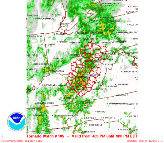
URGENT - IMMEDIATE BROADCAST REQUESTED
Tornado Watch Number 105
NWS Storm Prediction Center Norman OK
405 PM EDT Thu Apr 11 2024

The NWS Storm Prediction Center has issued a

* Tornado Watch for portions of
  Eastern Kentucky
  Southeast Ohio
  Southwest Pennsylvania
  Far Western Virginia
  West Virginia

* Effective this Thursday afternoon and evening from 405 PM until
  900 PM EDT.

* Primary threats include...
  A few tornadoes possible
  Scattered damaging wind gusts to 70 mph possible
  Isolated large hail events to 1.5 inches in diameter possible

SUMMARY...At least widely scattered severe storms are expected to
develop and race generally northeastward through late afternoon and
evening, potentially including some supercells capable of a tornado
risk as well as damaging winds and possibly some hail.

The tornado watch area is approximately along and 65 statute miles
east and west of a line from 45 miles east southeast of Jackson KY
to 15 miles east northeast of Wheeling WV. For a complete depiction
of the watch see the associated watch outline update (WOUS64 KWNS
WOU5).

PRECAUTIONARY/PREPAREDNESS ACTIONS...

REMEMBER...A Tornado Watch means conditions are favorable for
tornadoes and severe thunderstorms in and close to the watch
area. Persons in these areas should be on the lookout for
threatening weather conditions and listen for later statements
and possible warnings.

&&

AVIATION...Tornadoes and a few severe thunderstorms with hail
surface and aloft to 1.5 inches. Extreme turbulence and surface wind
gusts to 60 knots. A few cumulonimbi with maximum tops to 450. Mean
storm motion vector 23035.

...Guyer
Read morehttps://www.spc.noaa.gov/products/watch/ww0105.html
|
|


CMS The Best Conveyancing solicitors conveyancing quotes throughout the UK
For any webhosting enquiries please email webmaster@aus-city.com
|
|
Entire Thread
|
 SPC Tornado Watch 105
|
Webmaster
|
Thu 11 Apr 2024 08:05:PM
|
|
Forums60
Topics687,219
Posts721,830
Members2,957
| |
Most Online3,142
Jan 16th, 2023
|
|
|
|
|
Copyright 1996 - 2023 by David Cottle. Designed by David Bate Jr. All Rights Reserved.
By using this forum, the user agrees not to transfer any data or technical information received under the agreement, to any other entity without the express approval of the AUS-CITY Forum Admins and/or authors of individual posts (Forum Admins and DoD/USSPACECOM for the analysis of satellite tracking data).
Two-line elements (TLE) and all other satellite data presented and distributed via this forum and e-mail lists of AUS-CITY are distributed with permission from DoD/USSTRATCOM.

Reprise Hosting

|

|


 - Click image for larger picture.")


