|
|
|
0 members (),
588
guests, and
28
robots. |
|
Key:
Admin,
Global Mod,
Mod
|
|
S |
M |
T |
W |
T |
F |
S |
|
|
|
|
1
|
2
|
3
|
4
|
|
5
|
6
|
7
|
8
|
9
|
10
|
11
|
|
12
|
13
|
14
|
15
|
16
|
17
|
18
|
|
19
|
20
|
21
|
22
|
23
|
24
|
25
|
|
26
|
27
|
28
|
29
|
30
|
31
|
|
|
There are no members with birthdays on this day. |

#717564
Tue 02 Apr 2024 03:28:AM
|
Joined: Feb 2001
Posts: 381,903
Launch Director
|
OP

Launch Director
Joined: Feb 2001
Posts: 381,903 |
SPC Tornado Watch 68WW 68 TORNADO IL MO 012150Z - 020500Z 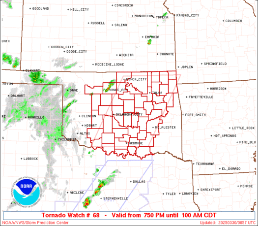
URGENT - IMMEDIATE BROADCAST REQUESTED
Tornado Watch Number 68
NWS Storm Prediction Center Norman OK
450 PM CDT Mon Apr 1 2024

The NWS Storm Prediction Center has issued a

* Tornado Watch for portions of
  Central Illinois
  Eastern Missouri

* Effective this Monday afternoon from 450 PM until Midnight CDT.

* Primary threats include...
  A few tornadoes and a couple intense tornadoes possible
  Scattered large hail and isolated very large hail events to 2.5
    inches in diameter likely
  Scattered damaging wind gusts to 70 mph likely

SUMMARY...Thunderstorms will intensify this afternoon and evening,
building eastward along a boundary across central Missouri/Illinois.
 Supercells capable of large hail, damaging winds, and a few
tornadoes are possible.

The tornado watch area is approximately along and 50 statute miles
north and south of a line from 40 miles southwest of Jefferson City
MO to 35 miles south of Danville IL. For a complete depiction of the
watch see the associated watch outline update (WOUS64 KWNS WOU8).

PRECAUTIONARY/PREPAREDNESS ACTIONS...

REMEMBER...A Tornado Watch means conditions are favorable for
tornadoes and severe thunderstorms in and close to the watch
area. Persons in these areas should be on the lookout for
threatening weather conditions and listen for later statements
and possible warnings.

&&

OTHER WATCH INFORMATION...CONTINUE...WW 64...WW 65...WW 66...WW
67...

AVIATION...Tornadoes and a few severe thunderstorms with hail
surface and aloft to 2.5 inches. Extreme turbulence and surface wind
gusts to 60 knots. A few cumulonimbi with maximum tops to 500. Mean
storm motion vector 25030.

...Hart
Read morehttps://www.spc.noaa.gov/products/watch/ww0068.html
|
|


CMS The Best Conveyancing solicitors conveyancing quotes throughout the UK
For any webhosting enquiries please email webmaster@aus-city.com
|
|
Forums60
Topics684,791
Posts719,402
Members2,957
| |
Most Online3,142
Jan 16th, 2023
|
|
|
|
|
Copyright 1996 - 2023 by David Cottle. Designed by David Bate Jr. All Rights Reserved.
By using this forum, the user agrees not to transfer any data or technical information received under the agreement, to any other entity without the express approval of the AUS-CITY Forum Admins and/or authors of individual posts (Forum Admins and DoD/USSPACECOM for the analysis of satellite tracking data).
Two-line elements (TLE) and all other satellite data presented and distributed via this forum and e-mail lists of AUS-CITY are distributed with permission from DoD/USSTRATCOM.

Reprise Hosting

|

|


 - Click image for larger picture.")


