|
|
|
0 members (),
521
guests, and
28
robots. |
|
Key:
Admin,
Global Mod,
Mod
|
|
S |
M |
T |
W |
T |
F |
S |
|
|
|
|
1
|
2
|
3
|
4
|
|
5
|
6
|
7
|
8
|
9
|
10
|
11
|
|
12
|
13
|
14
|
15
|
16
|
17
|
18
|
|
19
|
20
|
21
|
22
|
23
|
24
|
25
|
|
26
|
27
|
28
|
29
|
30
|
31
|
|
|
There are no members with birthdays on this day. |

#717575
Tue 02 Apr 2024 04:30:AM
|
Joined: Feb 2001
Posts: 381,903
Launch Director
|
OP

Launch Director
Joined: Feb 2001
Posts: 381,903 |
SPC MD 335MD 0335 CONCERNING SEVERE THUNDERSTORM WATCH 70... FOR PORTIONS OF SOUTHEASTERN OKLAHOMA INTO NORTHEASTERN TEXAS AND FAR WESTERN ARKANSAS 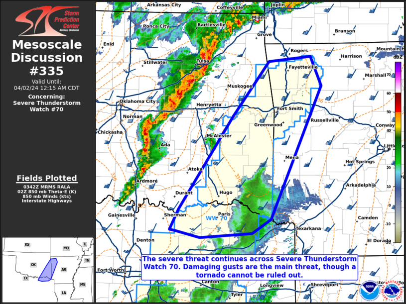
Mesoscale Discussion 0335
NWS Storm Prediction Center Norman OK
1045 PM CDT Mon Apr 01 2024

Areas affected...portions of southeastern Oklahoma into northeastern
Texas and far western Arkansas

Concerning...Severe Thunderstorm Watch 70...

Valid 020345Z - 020515Z

The severe weather threat for Severe Thunderstorm Watch 70
continues.

SUMMARY...The severe threat continues across Severe Thunderstorm
Watch 70. The main severe threat exists across northern portions of
the watch as a line of storms approaches from the west. Damaging
gusts are the main threat, though a tornado cannot be ruled out.

DISCUSSION...The earlier QLCS with embedded supercells across
northern TX has diminished in intensity given increasing inhibition.
However, a pronounced QLCS is in progress across central OK, and
this convection may move into Severe Thunderstorm Watch 70 over the
next few hours with a damaging gust threat. Portions of the watch
across eastern OK into western AR will most likely experience this
QLCS later this evening. It is unclear how far south the QLCS will
build into TX, so the severe threat is more conditional across the
TX portion of the watch. Regional VADs, 03Z mesoanalysis, and RAP
forecast soundings all show elongated hodographs with decent
low-level curvature. However, CINH is increasing above the boundary
layer given nocturnal cooling, tempering the tornado threat.
Nonetheless, a tornado cannot be completely ruled out if a QLCS
circulation can ingest any surface-based parcels.

..Squitieri.. 04/02/2024

...Please see www.spc.noaa.gov for graphic product...

ATTN...WFO...LZK...SHV...TSA...FWD...OUN...

LAT...LON   33639449 33409486 33329588 33439637 33469647 33789630
            35309524 36219452 36299369 35819349 33639449
Read morehttps://www.spc.noaa.gov/products/md/md0335.html
|
|


CMS The Best Conveyancing solicitors conveyancing quotes throughout the UK
For any webhosting enquiries please email webmaster@aus-city.com
|
|
Forums60
Topics684,790
Posts719,401
Members2,957
| |
Most Online3,142
Jan 16th, 2023
|
|
|
|
|
Copyright 1996 - 2023 by David Cottle. Designed by David Bate Jr. All Rights Reserved.
By using this forum, the user agrees not to transfer any data or technical information received under the agreement, to any other entity without the express approval of the AUS-CITY Forum Admins and/or authors of individual posts (Forum Admins and DoD/USSPACECOM for the analysis of satellite tracking data).
Two-line elements (TLE) and all other satellite data presented and distributed via this forum and e-mail lists of AUS-CITY are distributed with permission from DoD/USSTRATCOM.

Reprise Hosting

|

|


 - Click image for larger picture.")


