|
0 members (),
435
guests, and
28
robots. |
|
Key:
Admin,
Global Mod,
Mod
|
|
S |
M |
T |
W |
T |
F |
S |
|
|
|
|
1
|
2
|
3
|
4
|
|
5
|
6
|
7
|
8
|
9
|
10
|
11
|
|
12
|
13
|
14
|
15
|
16
|
17
|
18
|
|
19
|
20
|
21
|
22
|
23
|
24
|
25
|
|
26
|
27
|
28
|
29
|
30
|
31
|
|
|
There are no members with birthdays on this day. |

#720928
Fri 26 Apr 2024 06:15:PM
|
Joined: Feb 2001
Posts: 381,903
Launch Director
|
OP

Launch Director
Joined: Feb 2001
Posts: 381,903 |
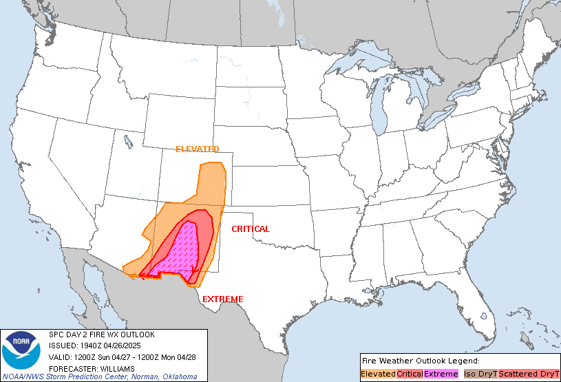
SPC Day 2 Fire Weather OutlookSPC Day 2 Fire Weather Outlook 
Day 2 Fire Weather Outlook
NWS Storm Prediction Center Norman OK
0114 PM CDT Fri Apr 26 2024

Valid 271200Z - 281200Z

...CRITICAL FIRE WEATHER AREA FOR PORTIONS OF THE SOUTHERN HIGH
PLAINS...

No changes. See previous discussion below.

..Bentley.. 04/26/2024

.PREV DISCUSSION... /ISSUED 0152 AM CDT Fri Apr 26 2024/

...Synopsis...
A strong mid-level jet streak will round the western trough on
Saturday, with strong lee cyclogenesis resulting across the High
Plains. Strengthening flow amid very dry conditions will lead to
Critical fire weather concerns across portions of the southern High
Plains into the central High Plains.

...Southern and Central High Plains...
A deeply mixed airmass is expected to be in place by Saturday
afternoon across portions of eastern New Mexico into far
southeastern Colorado and eastward into the Oklahoma/Texas
Panhandles. In these regions, sustained surface winds 20-30 mph will
overlap afternoon relative humidity reductions to around 5-10
percent. While some spotty Extremely Critical conditions are
possible, fuels do not yet support inclusion of an Extremely
Critical area at this time. Conditions will be monitored for higher
end potential.

...Please see www.spc.noaa.gov/fire for graphic product...
Read morehttps://www.spc.noaa.gov/products/fire_wx/fwdy2.html
|
|


CMS The Best Conveyancing solicitors conveyancing quotes throughout the UK
For any webhosting enquiries please email webmaster@aus-city.com
|
|
Forums60
Topics685,338
Posts719,949
Members2,957
| |
Most Online3,142
Jan 16th, 2023
|
|
|