|
0 members (),
268
guests, and
32
robots. |
|
Key:
Admin,
Global Mod,
Mod
|
|
S |
M |
T |
W |
T |
F |
S |
|
|
|
|
1
|
2
|
3
|
4
|
|
5
|
6
|
7
|
8
|
9
|
10
|
11
|
|
12
|
13
|
14
|
15
|
16
|
17
|
18
|
|
19
|
20
|
21
|
22
|
23
|
24
|
25
|
|
26
|
27
|
28
|
29
|
30
|
31
|
|
|
There are no members with birthdays on this day. |

#721890
Wed 08 May 2024 09:37:PM
|
Joined: Feb 2001
Posts: 381,903
Launch Director
|
OP

Launch Director
Joined: Feb 2001
Posts: 381,903 |
SPC Tornado Watch 209WW 209 TORNADO TN 081950Z - 090200Z 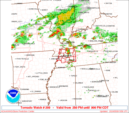
URGENT - IMMEDIATE BROADCAST REQUESTED
Tornado Watch Number 209
NWS Storm Prediction Center Norman OK
250 PM CDT Wed May 8 2024

The NWS Storm Prediction Center has issued a

* Tornado Watch for portions of
  Northwest Tennessee

* Effective this Wednesday afternoon and evening from 250 PM
  until 900 PM CDT.

* Primary threats include...
  A few tornadoes likely with a couple intense tornadoes possible
  Scattered large hail and isolated very large hail events to 2.5
    inches in diameter likely
  Scattered damaging wind gusts to 70 mph likely

SUMMARY...A few supercells are expected this afternoon/evening along
a remnant outflow boundary across northwest Tennessee.  A few
tornadoes, including a strong (EF2+) tornado or two, large hail up
to 2.5 inches in diameter and damaging gusts to 70 mph will be
possible.

The tornado watch area is approximately along and 35 statute miles
north and south of a line from 10 miles west northwest of Dyersburg
TN to 60 miles east northeast of Jackson TN. For a complete
depiction of the watch see the associated watch outline update
(WOUS64 KWNS WOU9).

PRECAUTIONARY/PREPAREDNESS ACTIONS...

REMEMBER...A Tornado Watch means conditions are favorable for
tornadoes and severe thunderstorms in and close to the watch
area. Persons in these areas should be on the lookout for
threatening weather conditions and listen for later statements
and possible warnings.

&&

OTHER WATCH INFORMATION...CONTINUE...WW 203...WW 204...WW
205...WW 206...WW 207...WW 208...

AVIATION...Tornadoes and a few severe thunderstorms with hail
surface and aloft to 2.5 inches. Extreme turbulence and surface wind
gusts to 60 knots. A few cumulonimbi with maximum tops to 550. Mean
storm motion vector 27025.

...Thompson
Read morehttps://www.spc.noaa.gov/products/watch/ww0209.html
|
|


CMS The Best Conveyancing solicitors conveyancing quotes throughout the UK
For any webhosting enquiries please email webmaster@aus-city.com
|
|
Forums60
Topics687,233
Posts721,844
Members2,957
| |
Most Online3,142
Jan 16th, 2023
|
|
|


 - Click image for larger picture.")


