|
0 members (),
249
guests, and
38
robots. |
|
Key:
Admin,
Global Mod,
Mod
|
|
S |
M |
T |
W |
T |
F |
S |
|
|
|
|
1
|
2
|
3
|
4
|
|
5
|
6
|
7
|
8
|
9
|
10
|
11
|
|
12
|
13
|
14
|
15
|
16
|
17
|
18
|
|
19
|
20
|
21
|
22
|
23
|
24
|
25
|
|
26
|
27
|
28
|
29
|
30
|
31
|
|
|
There are no members with birthdays on this day. |

#721893
Wed 08 May 2024 09:40:PM
|
Joined: Feb 2001
Posts: 381,903
Launch Director
|
OP

Launch Director
Joined: Feb 2001
Posts: 381,903 |
SPC Tornado Watch 206WW 206 TORNADO IL IN KY TN 081815Z - 090200Z 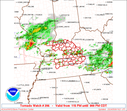
URGENT - IMMEDIATE BROADCAST REQUESTED
Tornado Watch Number 206
NWS Storm Prediction Center Norman OK
115 PM CDT Wed May 8 2024

The NWS Storm Prediction Center has issued a

* Tornado Watch for portions of
  Southern Illinois
  Southern Indiana
  Central Kentucky
  Middle Tennessee

* Effective this Wednesday afternoon and evening from 115 PM
  until 900 PM CDT.

* Primary threats include...
  A few tornadoes likely with a couple intense tornadoes possible
  Widespread damaging winds and isolated significant gusts to 80
    mph likely
  Scattered large hail and isolated very large hail events to 2.5
    inches in diameter likely

SUMMARY...Supercells are forecast to continue to develop and
intensify across the Watch area as the airmass recovers in wake of
an earlier thunderstorm complex.  Large to very large hail,
tornadoes, and damaging gusts are possible.  A strong tornado is
possible with any mature and intense supercell.

The tornado watch area is approximately along and 70 statute miles
north and south of a line from 55 miles northwest of Fort Campbell
KY to 55 miles north of Crossville TN. For a complete depiction of
the watch see the associated watch outline update (WOUS64 KWNS
WOU6).

PRECAUTIONARY/PREPAREDNESS ACTIONS...

REMEMBER...A Tornado Watch means conditions are favorable for
tornadoes and severe thunderstorms in and close to the watch
area. Persons in these areas should be on the lookout for
threatening weather conditions and listen for later statements
and possible warnings.

&&

OTHER WATCH INFORMATION...CONTINUE...WW 202...WW 203...WW
204...WW 205...

AVIATION...Tornadoes and a few severe thunderstorms with hail
surface and aloft to 2.5 inches. Extreme turbulence and surface wind
gusts to 70 knots. A few cumulonimbi with maximum tops to 500. Mean
storm motion vector 24035.

...Smith
Read morehttps://www.spc.noaa.gov/products/watch/ww0206.html
|
|


CMS The Best Conveyancing solicitors conveyancing quotes throughout the UK
For any webhosting enquiries please email webmaster@aus-city.com
|
|
Forums60
Topics687,233
Posts721,844
Members2,957
| |
Most Online3,142
Jan 16th, 2023
|
|
|


 - Click image for larger picture.")


