|
|
|
0 members (),
484
guests, and
28
robots. |
|
Key:
Admin,
Global Mod,
Mod
|
|
S |
M |
T |
W |
T |
F |
S |
|
|
1
|
2
|
3
|
4
|
5
|
6
|
|
7
|
8
|
9
|
10
|
11
|
12
|
13
|
|
14
|
15
|
16
|
17
|
18
|
19
|
20
|
|
21
|
22
|
23
|
24
|
25
|
26
|
27
|
|
28
|
29
|
30
|
|
|
|
|
|
There are no members with birthdays on this day. |
 SPC Tornado Watch 142 Status Reports
Webmaster
Yesterday at 09:40 PM
SPC Tornado Watch 142 Status Reports
Webmaster
Yesterday at 09:40 PM
SPC Tornado Watch 142 Status ReportsWW 0142 Status Updates 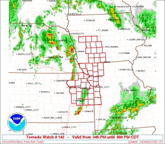
STATUS REPORT ON WW 142

THE SEVERE WEATHER THREAT CONTINUES ACROSS THE ENTIRE WATCH AREA.

..WENDT..04/26/24

ATTN...WFO...DMX...TOP...EAX...


STATUS REPORT FOR WT 142

SEVERE WEATHER THREAT CONTINUES FOR THE FOLLOWING AREAS

IAC001-003-009-027-029-039-047-049-053-073-077-121-159-173-175-
262240-

IA
.    IOWA COUNTIES INCLUDED ARE

ADAIR                ADAMS               AUDUBON
CARROLL              CASS                CLARKE
CRAWFORD             DALLAS              DECATUR
GREENE               GUTHRIE             MADISON
RINGGOLD             TAYLOR              UNION


KSC003-005-013-031-043-045-059-085-087-091-103-107-111-121-131-
139-149-177-197-209-262240-

KS
.    KANSAS COUNTIES INCLUDED ARE

ANDERSON             ATCHISON            BROWN
COFFEY               DONIPHAN            DOUGLAS
FRANKLIN             JACKSON             JEFFERSON
JOHNSON              LEAVENWORTH         LINN
LYON                 MIAMI               NEMAHA
OSAGE                POTTAWATOMIE        SHAWNEE
WABAUNSEE            WYANDOTTE
Read morehttps://www.spc.noaa.gov/products/watch/ws0142.html
0
13
Read More
|
SPC Tornado Watch 142
Webmaster
Yesterday at 09:40 PM
SPC Tornado Watch 142WW 142 TORNADO IA KS MO 262045Z - 270200Z
URGENT - IMMEDIATE BROADCAST REQUESTED
Tornado Watch Number 142
NWS Storm Prediction Center Norman OK
345 PM CDT Fri Apr 26 2024

The NWS Storm Prediction Center has issued a

* Tornado Watch for portions of
  Southwest Iowa
  Eastern Kansas
  Northwest Missouri

* Effective this Friday afternoon and evening from 345 PM until
  900 PM CDT.

* Primary threats include...
  A few tornadoes likely with a couple intense tornadoes possible
  Scattered large hail and isolated very large hail events to 2.5
    inches in diameter likely
  Scattered damaging wind gusts to 70 mph likely

SUMMARY...Isolated supercell thunderstorms over eastern Nebraska
will northeastward, while other storms form over eastern Kansas.
All of these storms will track across the watch area through early
evening, posing a risk of large hail and a few tornadoes.

The tornado watch area is approximately along and 45 statute miles
east and west of a line from 35 miles east northeast of Denison IA
to 45 miles east southeast of Emporia KS. For a complete depiction
of the watch see the associated watch outline update (WOUS64 KWNS
WOU2).

PRECAUTIONARY/PREPAREDNESS ACTIONS...

REMEMBER...A Tornado Watch means conditions are favorable for
tornadoes and severe thunderstorms in and close to the watch
area. Persons in these areas should be on the lookout for
threatening weather conditions and listen for later statements
and possible warnings.

&&

OTHER WATCH INFORMATION...CONTINUE...WW 139...WW 140...WW 141...

AVIATION...Tornadoes and a few severe thunderstorms with hail
surface and aloft to 2.5 inches. Extreme turbulence and surface wind
gusts to 60 knots. A few cumulonimbi with maximum tops to 500. Mean
storm motion vector 23030.

...Hart
Read morehttps://www.spc.noaa.gov/products/watch/ww0142.html
0
12
Read More
|
SPC Tornado Watch 141 Status Reports
Webmaster
Yesterday at 09:39 PM
SPC Tornado Watch 141 Status ReportsWW 0141 Status Updates 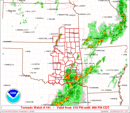
STATUS REPORT ON WW 141

SEVERE WEATHER THREAT CONTINUES RIGHT OF A LINE FROM 40 N ADM TO
20 SSE CQB TO 30 WNW TUL TO 40 E ICT.

..WENDT..04/26/24

ATTN...WFO...ICT...SGF...TSA...OUN...


STATUS REPORT FOR WT 141

SEVERE WEATHER THREAT CONTINUES FOR THE FOLLOWING AREAS

KSC001-011-019-021-037-049-073-099-125-133-205-207-262240-

KS
.    KANSAS COUNTIES INCLUDED ARE

ALLEN                BOURBON             CHAUTAUQUA
CHEROKEE             CRAWFORD            ELK
GREENWOOD            LABETTE             MONTGOMERY
NEOSHO               WILSON              WOODSON


OKC001-005-013-019-021-023-029-035-037-041-061-063-069-077-079-
085-091-095-097-099-101-105-107-111-113-115-121-123-125-127-131-
133-135-143-145-147-262240-

OK
.    OKLAHOMA COUNTIES INCLUDED ARE

ADAIR                ATOKA               BRYAN
CARTER               CHEROKEE            CHOCTAW
COAL                 CRAIG               CREEK
DELAWARE             HASKELL             HUGHES
JOHNSTON             LATIMER             LE FLORE
LOVE                 MCINTOSH            MARSHALL
MAYES                MURRAY              MUSKOGEE
Read morehttps://www.spc.noaa.gov/products/watch/ws0141.html
0
11
Read More
|
SPC Tornado Watch 141
Webmaster
Yesterday at 09:39 PM
SPC Tornado Watch 141WW 141 TORNADO KS OK 261910Z - 270200Z
URGENT - IMMEDIATE BROADCAST REQUESTED
Tornado Watch Number 141
NWS Storm Prediction Center Norman OK
210 PM CDT Fri Apr 26 2024

The NWS Storm Prediction Center has issued a

* Tornado Watch for portions of
  Southeast Kansas
  Eastern Oklahoma

* Effective this Friday afternoon and evening from 210 PM until
  900 PM CDT.

* Primary threats include...
  A few tornadoes likely with a couple intense tornadoes possible
  Scattered large hail and isolated very large hail events to 3
    inches in diameter likely
  Scattered damaging wind gusts to 70 mph possible

SUMMARY...Isolated thunderstorms are beginning to form along a
dryline over southeast Kansas and central Oklahoma.  This activity
may remain widely scattered, but those storms that form will pose a
risk of very large hail and a few tornadoes.  Strong tornadoes are
possible.

The tornado watch area is approximately along and 65 statute miles
east and west of a line from 25 miles north northeast of Chanute KS
to 20 miles east of Durant OK. For a complete depiction of the watch
see the associated watch outline update (WOUS64 KWNS WOU1).

PRECAUTIONARY/PREPAREDNESS ACTIONS...

REMEMBER...A Tornado Watch means conditions are favorable for
tornadoes and severe thunderstorms in and close to the watch
area. Persons in these areas should be on the lookout for
threatening weather conditions and listen for later statements
and possible warnings.

&&

OTHER WATCH INFORMATION...CONTINUE...WW 139...WW 140...

AVIATION...Tornadoes and a few severe thunderstorms with hail
surface and aloft to 3 inches. Extreme turbulence and surface wind
gusts to 60 knots. A few cumulonimbi with maximum tops to 500. Mean
storm motion vector 25035.

...Hart
Read morehttps://www.spc.noaa.gov/products/watch/ww0141.html
0
12
Read More
|
SPC Tornado Watch 139 Status Reports
Webmaster
Yesterday at 09:33 PM
SPC Tornado Watch 139 Status ReportsWW 0139 Status Updates 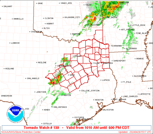
STATUS REPORT ON WW 139

THE SEVERE WEATHER THREAT CONTINUES ACROSS THE ENTIRE WATCH AREA.

..WENDT..04/26/24

ATTN...WFO...SHV...FWD...


STATUS REPORT FOR WT 139

SEVERE WEATHER THREAT CONTINUES FOR THE FOLLOWING AREAS

OKC089-262240-

OK
.    OKLAHOMA COUNTIES INCLUDED ARE

MCCURTAIN


TXC001-027-035-037-063-067-073-085-099-113-119-139-145-147-159-
161-183-193-203-213-217-223-231-251-257-277-281-289-293-309-315-
331-333-343-349-365-379-387-395-397-401-423-425-439-449-459-467-
499-262240-

TX
.    TEXAS COUNTIES INCLUDED ARE

ANDERSON             BELL                BOSQUE
BOWIE                CAMP                CASS
CHEROKEE             COLLIN              CORYELL
DALLAS               DELTA               ELLIS
FALLS                FANNIN              FRANKLIN
FREESTONE            GREGG               HAMILTON
HARRISON             HENDERSON           HILL
HOPKINS              HUNT                JOHNSON
KAUFMAN              LAMAR               LAMPASAS
LEON                 LIMESTONE           MCLENNAN
Read morehttps://www.spc.noaa.gov/products/watch/ws0139.html
0
11
Read More
|
SPC Tornado Watch 139
Webmaster
Yesterday at 09:33 PM
SPC Tornado Watch 139WW 139 TORNADO OK TX 261510Z - 262300Z
URGENT - IMMEDIATE BROADCAST REQUESTED
Tornado Watch Number 139
NWS Storm Prediction Center Norman OK
1010 AM CDT Fri Apr 26 2024

The NWS Storm Prediction Center has issued a

* Tornado Watch for portions of
  Southeast Oklahoma
  Central and Northeast Texas

* Effective this Friday morning and evening from 1010 AM until
  600 PM CDT.

* Primary threats include...
  A few tornadoes possible
  Scattered large hail and isolated very large hail events to 2.5
    inches in diameter possible
  Scattered damaging wind gusts to 70 mph possible

SUMMARY...Thunderstorms are expected increase in coverage and
intensity through the late morning and afternoon, with a few severe
thunderstorms possible.  Large hail, damaging winds, and a few
tornadoes may occur.

The tornado watch area is approximately along and 60 statute miles
north and south of a line from 50 miles west of Temple TX to 65
miles north northeast of Longview TX. For a complete depiction of
the watch see the associated watch outline update (WOUS64 KWNS
WOU9).

PRECAUTIONARY/PREPAREDNESS ACTIONS...

REMEMBER...A Tornado Watch means conditions are favorable for
tornadoes and severe thunderstorms in and close to the watch
area. Persons in these areas should be on the lookout for
threatening weather conditions and listen for later statements
and possible warnings.

&&

OTHER WATCH INFORMATION...CONTINUE...WW 138...

AVIATION...Tornadoes and a few severe thunderstorms with hail
surface and aloft to 2.5 inches. Extreme turbulence and surface wind
gusts to 60 knots. A few cumulonimbi with maximum tops to 500. Mean
storm motion vector 25030.

...Hart
Read morehttps://www.spc.noaa.gov/products/watch/ww0139.html
0
12
Read More
|
SPC Tornado Watch 140 Status Reports
Webmaster
Yesterday at 09:31 PM
SPC Tornado Watch 140 Status ReportsWW 0140 Status Updates 
STATUS REPORT ON WW 140

SEVERE WEATHER THREAT CONTINUES RIGHT OF A LINE FROM 35 NE MHK TO
25 SE BIE TO 10 NNE LNK TO 20 WSW OLU TO 40 N GRI TO 40 NNE ONL.

..WENDT..04/26/24

ATTN...WFO...OAX...FSD...TOP...EAX...GID...LBF...


STATUS REPORT FOR WT 140

SEVERE WEATHER THREAT CONTINUES FOR THE FOLLOWING AREAS

IAC071-085-129-133-137-145-155-165-193-262240-

IA
.    IOWA COUNTIES INCLUDED ARE

FREMONT              HARRISON            MILLS
MONONA               MONTGOMERY          PAGE
POTTAWATTAMIE        SHELBY              WOODBURY


NEC003-011-021-023-025-027-037-039-043-051-053-055-097-107-119-
127-131-133-139-141-147-153-155-167-173-177-179-262240-

NE
.    NEBRASKA COUNTIES INCLUDED ARE

ANTELOPE             BOONE               BURT
BUTLER               CASS                CEDAR
COLFAX               CUMING              DAKOTA
DIXON                DODGE               DOUGLAS
JOHNSON              KNOX                MADISON
NEMAHA               OTOE                PAWNEE
PIERCE               PLATTE              RICHARDSON
SARPY                SAUNDERS            STANTON
THURSTON             WASHINGTON          WAYNE
Read morehttps://www.spc.noaa.gov/products/watch/ws0140.html
0
10
Read More
|
SPC Tornado Watch 140
Webmaster
Yesterday at 09:31 PM
SPC Tornado Watch 140WW 140 TORNADO IA KS MO NE 261755Z - 270000Z
URGENT - IMMEDIATE BROADCAST REQUESTED
Tornado Watch Number 140
NWS Storm Prediction Center Norman OK
1255 PM CDT Fri Apr 26 2024

The NWS Storm Prediction Center has issued a

* Tornado Watch for portions of
  Western Iowa
  Northeast Kansas
  Northwest Missouri
  Eastern Nebraska

* Effective this Friday afternoon and evening from 1255 PM until
  700 PM CDT.

* Primary threats include...
  A few tornadoes likely with a couple intense tornadoes possible
  Widespread large hail and isolated very large hail events to 3
    inches in diameter likely
  Scattered damaging wind gusts to 70 mph possible

SUMMARY...Thunderstorms are forecast to develop and spread across
the watch area this afternoon.  Supercells capable of very large
hail and a few tornadoes are the main threat.  A strong tornado is
possible.

The tornado watch area is approximately along and 80 statute miles
north and south of a line from 5 miles southwest of Burwell NE to 20
miles east northeast of Shenandoah IA. For a complete depiction of
the watch see the associated watch outline update (WOUS64 KWNS
WOU0).

PRECAUTIONARY/PREPAREDNESS ACTIONS...

REMEMBER...A Tornado Watch means conditions are favorable for
tornadoes and severe thunderstorms in and close to the watch
area. Persons in these areas should be on the lookout for
threatening weather conditions and listen for later statements
and possible warnings.

&&

OTHER WATCH INFORMATION...CONTINUE...WW 139...

AVIATION...Tornadoes and a few severe thunderstorms with hail
surface and aloft to 3 inches. Extreme turbulence and surface wind
gusts to 60 knots. A few cumulonimbi with maximum tops to 500. Mean
storm motion vector 22030.

...Hart
Read morehttps://www.spc.noaa.gov/products/watch/ww0140.html
0
12
Read More
|
Sunday: Light Rain Showers, Minimum Temperature: 3°C (38°F) Maximum Temperature: 12°C (53°F)
Webmaster
Yesterday at 09:00 PM
Maximum Temperature: 12°C (53°F), Minimum Temperature: 3°C (38°F), Wind Direction: Northerly, Wind Speed: 7mph, Visibility: Moderate, Pressure: 1005mb, Humidity: 75%, UV Risk: 3, Pollution: Low, Sunrise: 05:39 BST, Sunset: 20:35 BST Source: Sunday: Light Rain Showers, Minimum Temperature: 3°C (38°F) Maximum Temperature: 12°C (53°F)
0
5
Read More
|
Saturday: Light Cloud, Minimum Temperature: 5°C (41°F) Maximum Temperature: 12°C (53°F)
Webmaster
Yesterday at 09:00 PM
Maximum Temperature: 12°C (53°F), Minimum Temperature: 5°C (41°F), Wind Direction: North Easterly, Wind Speed: 9mph, Visibility: Good, Pressure: 1006mb, Humidity: 67%, UV Risk: 2, Pollution: Low, Sunrise: 05:41 BST, Sunset: 20:33 BST Source: Saturday: Light Cloud, Minimum Temperature: 5°C (41°F) Maximum Temperature: 12°C (53°F)
0
3
Read More
|
|
Forums60
Topics684,476
Posts719,086
Members2,957
| |
Most Online3,142
Jan 16th, 2023
|
|
|
|
|
Copyright 1996 - 2023 by David Cottle. Designed by David Bate Jr. All Rights Reserved.
By using this forum, the user agrees not to transfer any data or technical information received under the agreement, to any other entity without the express approval of the AUS-CITY Forum Admins and/or authors of individual posts (Forum Admins and DoD/USSPACECOM for the analysis of satellite tracking data).
Two-line elements (TLE) and all other satellite data presented and distributed via this forum and e-mail lists of AUS-CITY are distributed with permission from DoD/USSTRATCOM.


Reprise Hosting

|

|


 - Click image for larger picture.")


