|
|
|
0 members (),
559
guests, and
30
robots. |
|
Key:
Admin,
Global Mod,
Mod
|
|
S |
M |
T |
W |
T |
F |
S |
|
|
|
|
1
|
2
|
3
|
4
|
|
5
|
6
|
7
|
8
|
9
|
10
|
11
|
|
12
|
13
|
14
|
15
|
16
|
17
|
18
|
|
19
|
20
|
21
|
22
|
23
|
24
|
25
|
|
26
|
27
|
28
|
29
|
30
|
31
|
|
|
There are no members with birthdays on this day. |
evicted
by Webmaster - Thu 09 May 2024 02:00:AM
|
double oof
by Webmaster - Thu 09 May 2024 12:00:AM
|
|
|
80s moms
by Webmaster - Wed 08 May 2024 10:00:PM
|
SPC MD 707
by Webmaster - Wed 08 May 2024 09:56:PM
|
SPC MD 708
by Webmaster - Wed 08 May 2024 09:56:PM
|
SPC MD 709
by Webmaster - Wed 08 May 2024 09:56:PM
|
SPC MD 710
by Webmaster - Wed 08 May 2024 09:56:PM
|
SPC MD 705
by Webmaster - Wed 08 May 2024 09:56:PM
|
|
|
 SPC MD 707
Webmaster
Yesterday at 09:56 PM
SPC MD 707
Webmaster
Yesterday at 09:56 PM
SPC MD 707MD 0707 CONCERNING TORNADO WATCH 204...206...209... FOR MID-MS/LOWER OH AND TN VALLEYS 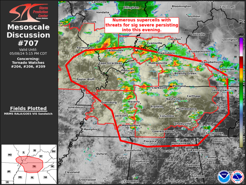
Mesoscale Discussion 0707
NWS Storm Prediction Center Norman OK
0341 PM CDT Wed May 08 2024

Areas affected...Mid-MS/Lower OH and TN Valleys

Concerning...Tornado Watch 204...206...209...

Valid 082041Z - 082215Z

The severe weather threat for Tornado Watch 204, 206, 209 continues.

SUMMARY...Numerous supercells are ongoing and will continue to pose
threats for significant severe weather during the next several
hours. Additional/expansion of tornado watches with south-southeast
extent and replacement/extension of parts of WW 206 (which is
scheduled to expire at 22Z) should be expected through early
evening.

DISCUSSION...An outbreak of supercells is underway from the Ozark
Plateau across the Mid-MS and Lower OH into the TN Valleys. These
storms will remain capable of producing tornadoes, large to very
large hail, and damaging winds for the next several hours. Greatest
tornado threat in the next few hours should be focused within three
regimes. One along, the residual outflow that extends in a
west/east-orientation across southern MO. The second with the
long-lived supercell cluster along the tight buoyancy gradient over
far southern IL into western KY. And the third area across middle TN
into south-central KY, where the strongest low-level shear exists
near/north of the modified convective outflow from earlier today.
The southern/eastern extent of the supercell development in the TN
Valley will likely necessitate additional tornado watches this
evening.

..Grams.. 05/08/2024

...Please see www.spc.noaa.gov for graphic product...

ATTN...WFO...MRX...JKL...FFC...LMK...OHX...HUN...PAH...MEG...
LSX...

LAT...LON   37438528 36958428 35728427 34738553 34698752 34878855
            35848891 36569004 36769057 37279082 37549053 37779005
            37928822 37438528
Read morehttps://www.spc.noaa.gov/products/md/md0707.html
0
15
Read More
|
SPC MD 708
Webmaster
Yesterday at 09:56 PM
SPC MD 708MD 0708 CONCERNING SEVERE POTENTIAL...WATCH UNLIKELY FOR SOUTHERN NEW ENGLAND 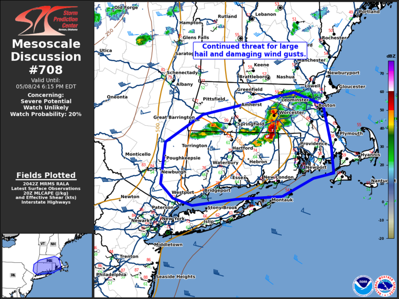
Mesoscale Discussion 0708
NWS Storm Prediction Center Norman OK
0344 PM CDT Wed May 08 2024

Areas affected...southern New England

Concerning...Severe potential...Watch unlikely

Valid 082044Z - 082215Z

Probability of Watch Issuance...20 percent

SUMMARY...The threat for large hail and damaging wind gusts
continues across southern New England.

DISCUSSION...A large supercell has developed in southern
Massachusetts where temperatures have warmed into the mid 70s with
dewpoints in the mid 60s. This has yielded 500 to 750 J/kg MLCAPE.
Despite this relatively weak instability, storm organization due to
70 knots of 0-6km shear (per BOX VWP), has been sufficient for
supercell maintenance. This intense storm will continue to pose a
severe wind and large hail threat as it moves east and the
downstream environment continues to destabilize ahead of it. In
addition, some storms are starting to develop to the west of this
supercell on the trailing outflow. Given a similarly warm and
unstable environment, one or two more strong to severe storms may
form and move along this outflow boundary this afternoon/evening.

..Bentley/Smith.. 05/08/2024

...Please see www.spc.noaa.gov for graphic product...

ATTN...WFO...BOX...OKX...ALY...

LAT...LON   41887391 42287322 42597149 42417095 41847080 41447076
            41387114 41127173 41087259 41007341 41097377 41297399
            41887391
Read morehttps://www.spc.noaa.gov/products/md/md0708.html
0
15
Read More
|
SPC MD 709
Webmaster
Yesterday at 09:56 PM
SPC MD 709MD 0709 CONCERNING TORNADO WATCH 205...208... FOR MUCH OF SOUTHERN MISSOURI INTO EASTERN OKLAHOMA AND WESTERN ARKANSAS 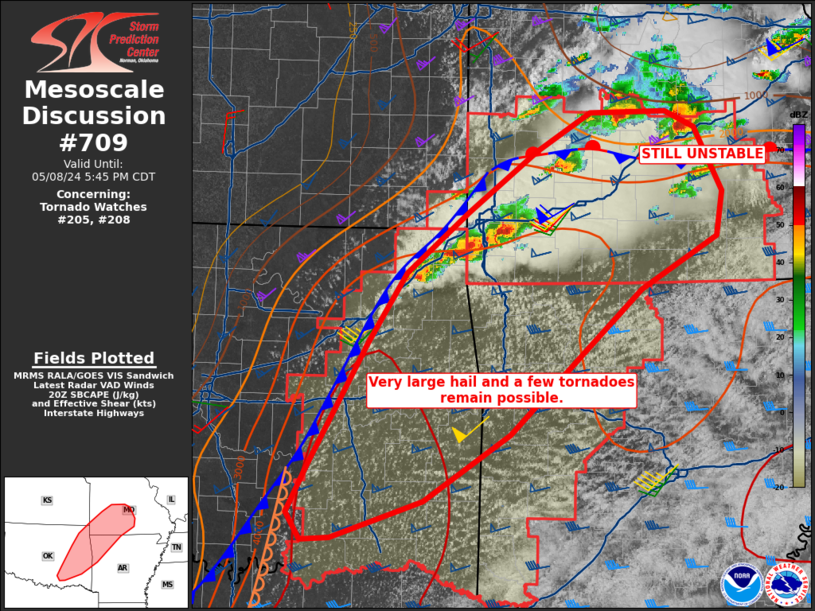
Mesoscale Discussion 0709
NWS Storm Prediction Center Norman OK
0350 PM CDT Wed May 08 2024

Areas affected...much of southern Missouri into eastern Oklahoma and
western Arkansas

Concerning...Tornado Watch 205...208...

Valid 082050Z - 082245Z

The severe weather threat for Tornado Watch 205, 208 continues.

SUMMARY...The threat of supercells producing very large hail,
tornadoes and damaging gusts persists from southern Missouri into
northeast Oklahoma, with additional storms anticipated farther
south.

DISCUSSION...Several supercells exist along a front from northeast
OK into southwest MO, with addition activity just on the cool/north
side of an east-west oriented outflow boundary from the earlier MCS.
This boundary appears to be mixing out, as temperatures are
recovering over south-central MO near the front.  Given time of day,
additional pockets of air mass recovery are possible with tornado
potential remaining.

Farther south, extreme instability persists over eastern OK into
western AR, and convergence near the cold front in OK is expected to
yield at least isolated supercells. These will have very large hail
potential, along with periodic tornado threat as 0-1 SRH remains
above 100 m2/s2.

..Jewell.. 05/08/2024

...Please see www.spc.noaa.gov for graphic product...

ATTN...WFO...LZK...SGF...TSA...OUN...

LAT...LON   34399660 34849637 35949572 36599528 37149459 37709381
            38069319 38079233 37919200 37339169 36919176 36439263
            35949319 35119412 34509509 34159612 34149644 34399660
Read morehttps://www.spc.noaa.gov/products/md/md0709.html
0
14
Read More
|
SPC MD 710
Webmaster
Yesterday at 09:56 PM
SPC MD 710MD 0710 CONCERNING SEVERE POTENTIAL...WATCH UNLIKELY FOR SOUTHEAST VIRGINIA 
Mesoscale Discussion 0710
NWS Storm Prediction Center Norman OK
0428 PM CDT Wed May 08 2024

Areas affected...southeast Virginia

Concerning...Severe potential...Watch unlikely

Valid 082128Z - 082230Z

Probability of Watch Issuance...5 percent

SUMMARY...An isolated storm across southeast Virginia will pose a
large hail and damaging wind threat through the evening.

DISCUSSION...A storm has formed within an area of weak low-level
confluence across south-central Virginia. The airmass ahead of this
storm is very unstable with 1500 to 2500 J/kg MLCAPE. This storm
appears to be mostly multi-cellular at this time which is consistent
with around 25 to 30 knots of effective shear (per SPC
mesoanalysis). Greater storm organization is possible as this storm
cluster moves east into greater instability this evening. The
environment will support both large hail and damaging wind gusts.
Given the isolated nature of the threat, no watch is expected.

..Bentley/Hart.. 05/08/2024

...Please see www.spc.noaa.gov for graphic product...

ATTN...WFO...AKQ...RAH...RNK...

LAT...LON   36827883 37707752 37747595 37027568 36537591 36527799
            36597882 36827883
Read morehttps://www.spc.noaa.gov/products/md/md0710.html
0
12
Read More
|
SPC MD 705
Webmaster
Yesterday at 09:56 PM
SPC MD 705MD 0705 CONCERNING SEVERE POTENTIAL...WATCH NEEDED SOON FOR PARTS OF NORTHERN INTO CENTRAL TEXAS 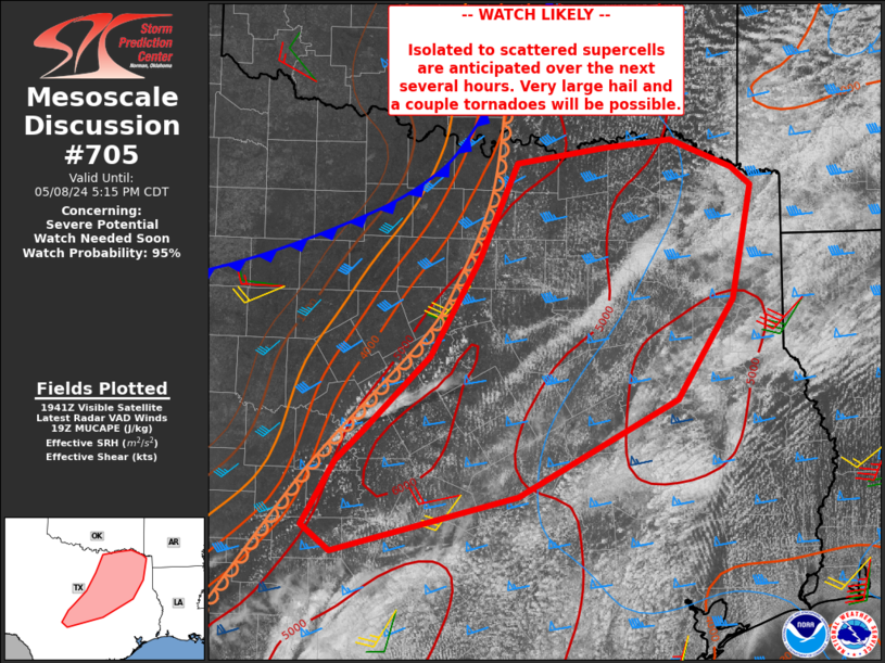
Mesoscale Discussion 0705
NWS Storm Prediction Center Norman OK
0246 PM CDT Wed May 08 2024

Areas affected...parts of northern into central Texas

Concerning...Severe potential...Watch needed soon

Valid 081946Z - 082215Z

Probability of Watch Issuance...95 percent

SUMMARY...Isolated to perhaps scattered severe storms capable of
very large hail and a tornado or two are expected over the next
several hours from parts of central into northeast Texas.

DISCUSSION...Deeper convection is beginning to form along the
dryline near San Saba and Mills Counties, with increasing Cu depth
extending northeastward along the dryline. A very moist and
extremely unstable air mass resides east of the dryline, with MLCAPE
in excess of 4000 J/kg. Effective deep-layer shear up to 50 kt with
a large cross component to the boundary will favor supercell storm
mode, with very large hail expected. A few tornadoes may occur as
well, perhaps brief but locally intense, given extreme instability
and sufficient low-level shear. An expansive, uncapped warm sector
suggests cells may remain severe for a long duration.

..Jewell/Smith.. 05/08/2024

...Please see www.spc.noaa.gov for graphic product...

ATTN...WFO...SHV...HGX...FWD...OUN...EWX...SJT...

LAT...LON   31569513 30709679 30209871 30439902 31019868 31289838
            31949771 32819719 33669681 33799589 33869520 33629455
            33469435 32449456 31569513
Read morehttps://www.spc.noaa.gov/products/md/md0705.html
0
15
Read More
|
SPC Day 3-8 Fire Weather Outlook
Webmaster
Yesterday at 09:49 PM
SPC Day 3-8 Fire Weather OutlookSPC Day 3-8 Fire Weather Outlook 
Day 3-8 Fire Weather Outlook
NWS Storm Prediction Center Norman OK
0444 PM CDT Wed May 08 2024

Valid 101200Z - 161200Z

Building surface high pressure will overspread the central/southern
Plains through much of the extended, keeping winds light and
limiting fire weather concerns where fuels are the driest.

Continued upper-level troughing over the western US and weak lee
troughing across the High Plains and will maintain areas of
dry/breezy conditions across eastern AZ/southwest NM. This may
support localized areas of Elevated fire weather concerns D3/Friday
and D4/Saturday. Rain chances are forecast to increase D3/Friday
across the Four Corners/southern High Plains, which should aid in
limiting fire potential in those regions.

As the western trough ejects into the Southern Plains D4/Saturday
into D5/Sunday, Critical conditions may return to far western
Texas/southern New Mexico. Potential for precipitation across this
region lowers confidence in including any areas with this outlook.

..Thornton.. 05/08/2024

...Please see www.spc.noaa.gov/fire for graphic product...
Read morehttps://www.spc.noaa.gov/products/exper/fire_wx/
0
12
Read More
|
SPC Tornado Watch 204 Status Reports
Webmaster
Yesterday at 09:42 PM
SPC Tornado Watch 204 Status ReportsWW 0204 Status Updates 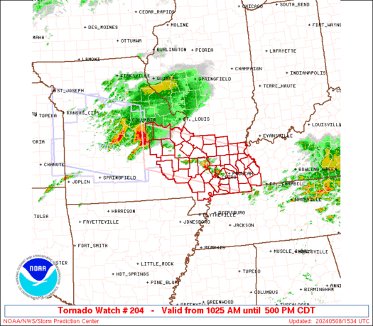
STATUS REPORT ON WW 204

THE SEVERE WEATHER THREAT CONTINUES ACROSS THE ENTIRE WATCH AREA.

..BENTLEY..05/08/24

ATTN...WFO...PAH...LSX...


STATUS REPORT FOR WT 204

SEVERE WEATHER THREAT CONTINUES FOR THE FOLLOWING AREAS

ILC003-055-059-069-077-087-127-133-145-151-153-157-165-181-199-
082240-

IL
.    ILLINOIS COUNTIES INCLUDED ARE

ALEXANDER            FRANKLIN            GALLATIN
HARDIN               JACKSON             JOHNSON
MASSAC               MONROE              PERRY
POPE                 PULASKI             RANDOLPH
SALINE               UNION               WILLIAMSON


KYC007-033-035-039-055-075-083-105-139-143-145-157-221-082240-

KY
.    KENTUCKY COUNTIES INCLUDED ARE

BALLARD              CALDWELL            CALLOWAY
CARLISLE             CRITTENDEN          FULTON
GRAVES               HICKMAN             LIVINGSTON
LYON                 MCCRACKEN           MARSHALL
TRIGG


MOC017-031-055-071-073-093-099-123-133-143-157-179-186-187-201-
Read morehttps://www.spc.noaa.gov/products/watch/ws0204.html
0
12
Read More
|
SPC Tornado Watch 204
Webmaster
Yesterday at 09:42 PM
SPC Tornado Watch 204WW 204 TORNADO IL KY MO 081525Z - 082200Z
URGENT - IMMEDIATE BROADCAST REQUESTED
Tornado Watch Number 204
NWS Storm Prediction Center Norman OK
1025 AM CDT Wed May 8 2024

The NWS Storm Prediction Center has issued a

* Tornado Watch for portions of
  Southern Illinois
  Western Kentucky
  Southeastern Missouri

* Effective this Wednesday morning and afternoon from 1025 AM
  until 500 PM CDT.

* Primary threats include...
  A few tornadoes likely with a couple intense tornadoes possible
  Widespread large hail and scattered very large hail events to 3
    inches in diameter likely
  Widespread damaging winds and isolated significant gusts to 80
    mph likely

SUMMARY...A supercell cluster in Missouri will likely persist
through the afternoon while spreading east-southeastward toward
southern Illinois, southeastern Missouri and western Kentucky, with
some potential for additional storm development this afternoon.  The
environment will become more favorable for surface-based storms
capable of producing tornadoes (a couple of which could be
strong/EF2+), severe wind swaths up to 80 mph, and very large hail
of 2-3 inches in diameter.

The tornado watch area is approximately along and 45 statute miles
north and south of a line from 5 miles south of Vichy MO to 40 miles
east of Paducah KY. For a complete depiction of the watch see the
associated watch outline update (WOUS64 KWNS WOU4).

PRECAUTIONARY/PREPAREDNESS ACTIONS...

REMEMBER...A Tornado Watch means conditions are favorable for
tornadoes and severe thunderstorms in and close to the watch
area. Persons in these areas should be on the lookout for
threatening weather conditions and listen for later statements
and possible warnings.

&&

OTHER WATCH INFORMATION...CONTINUE...WW 202...WW 203...

AVIATION...Tornadoes and a few severe thunderstorms with hail
surface and aloft to 3 inches. Extreme turbulence and surface wind
gusts to 70 knots. A few cumulonimbi with maximum tops to 550. Mean
storm motion vector 29030.

...Thompson
Read morehttps://www.spc.noaa.gov/products/watch/ww0204.html
0
9
Read More
|
SPC Tornado Watch 205 Status Reports
Webmaster
Yesterday at 09:41 PM
SPC Tornado Watch 205 Status ReportsWW 0205 Status Updates 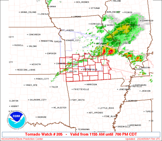
STATUS REPORT ON WW 205

SEVERE WEATHER THREAT CONTINUES RIGHT OF A LINE FROM 30 WNW JLN
TO 45 N JLN TO 40 SSE OJC.

..BENTLEY..05/08/24

ATTN...WFO...SGF...


STATUS REPORT FOR WT 205

SEVERE WEATHER THREAT CONTINUES FOR THE FOLLOWING AREAS

KSC021-082240-

KS
.    KANSAS COUNTIES INCLUDED ARE

CHEROKEE


MOC009-011-029-039-043-057-059-065-067-077-085-091-097-105-109-
119-145-149-153-161-167-169-185-203-209-213-215-217-225-229-
082240-

MO
.    MISSOURI COUNTIES INCLUDED ARE

BARRY                BARTON              CAMDEN
CEDAR                CHRISTIAN           DADE
DALLAS               DENT                DOUGLAS
GREENE               HICKORY             HOWELL
JASPER               LACLEDE             LAWRENCE
MCDONALD             NEWTON              OREGON
OZARK                PHELPS              POLK
PULASKI              ST. CLAIR           SHANNON
STONE                TANEY               TEXAS
VERNON               WEBSTER             WRIGHT
Read morehttps://www.spc.noaa.gov/products/watch/ws0205.html
0
10
Read More
|
SPC Tornado Watch 205
Webmaster
Yesterday at 09:41 PM
SPC Tornado Watch 205WW 205 TORNADO KS MO 081655Z - 090000Z
URGENT - IMMEDIATE BROADCAST REQUESTED
Tornado Watch Number 205
NWS Storm Prediction Center Norman OK
1155 AM CDT Wed May 8 2024

The NWS Storm Prediction Center has issued a

* Tornado Watch for portions of
  Extreme southeast Kansas
  Southern Missouri

* Effective this Wednesday morning and evening from 1155 AM until
  700 PM CDT.

* Primary threats include...
  A few tornadoes and a couple intense tornadoes possible
  Scattered damaging winds and isolated significant gusts to 75
    mph likely
  Scattered large hail and isolated very large hail events to 3
    inches in diameter likely

SUMMARY...Scattered supercell development is expected this afternoon
along and south of a slow-moving outflow boundary in Missouri.  The
storm environment will be most favorable for tornadoes close to the
stalling outflow boundary, where an isolated strong (EF2+) tornado
will be possible.  Otherwise, very large hail of 2-3 inches in
diameter will be possible with the supercells, and the potential for
damaging gusts up to 75 mph will increase with any upscale growth
into clusters.

The tornado watch area is approximately along and 50 statute miles
north and south of a line from 20 miles west northwest of Joplin MO
to 45 miles northeast of West Plains MO. For a complete depiction of
the watch see the associated watch outline update (WOUS64 KWNS
WOU5).

PRECAUTIONARY/PREPAREDNESS ACTIONS...

REMEMBER...A Tornado Watch means conditions are favorable for
tornadoes and severe thunderstorms in and close to the watch
area. Persons in these areas should be on the lookout for
threatening weather conditions and listen for later statements
and possible warnings.

&&

OTHER WATCH INFORMATION...CONTINUE...WW 202...WW 203...WW 204...

AVIATION...Tornadoes and a few severe thunderstorms with hail
surface and aloft to 3 inches. Extreme turbulence and surface wind
gusts to 65 knots. A few cumulonimbi with maximum tops to 550. Mean
storm motion vector 27030.

...Thompson
Read morehttps://www.spc.noaa.gov/products/watch/ww0205.html
0
2
Read More
|
SPC Tornado Watch 206 Status Reports
Webmaster
Yesterday at 09:40 PM
SPC Tornado Watch 206 Status ReportsWW 0206 Status Updates 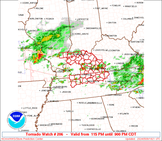
STATUS REPORT ON WW 206

THE SEVERE WEATHER THREAT CONTINUES ACROSS THE ENTIRE WATCH AREA.

..BENTLEY..05/08/24

ATTN...WFO...PAH...LMK...OHX...


STATUS REPORT FOR WT 206

SEVERE WEATHER THREAT CONTINUES FOR THE FOLLOWING AREAS

ILC065-193-082240-

IL
.    ILLINOIS COUNTIES INCLUDED ARE

HAMILTON             WHITE


INC123-129-147-163-173-082240-

IN
.    INDIANA COUNTIES INCLUDED ARE

PERRY                POSEY               SPENCER
VANDERBURGH          WARRICK


KYC001-003-009-027-031-053-057-059-061-085-087-091-093-099-101-
123-141-149-163-169-171-183-207-213-217-225-227-233-082240-

KY
.    KENTUCKY COUNTIES INCLUDED ARE

ADAIR                ALLEN               BARREN
BRECKINRIDGE         BUTLER              CLINTON
CUMBERLAND           DAVIESS             EDMONSON
Read morehttps://www.spc.noaa.gov/products/watch/ws0206.html
0
2
Read More
|
SPC Tornado Watch 206
Webmaster
Yesterday at 09:40 PM
SPC Tornado Watch 206WW 206 TORNADO IL IN KY TN 081815Z - 090200Z
URGENT - IMMEDIATE BROADCAST REQUESTED
Tornado Watch Number 206
NWS Storm Prediction Center Norman OK
115 PM CDT Wed May 8 2024

The NWS Storm Prediction Center has issued a

* Tornado Watch for portions of
  Southern Illinois
  Southern Indiana
  Central Kentucky
  Middle Tennessee

* Effective this Wednesday afternoon and evening from 115 PM
  until 900 PM CDT.

* Primary threats include...
  A few tornadoes likely with a couple intense tornadoes possible
  Widespread damaging winds and isolated significant gusts to 80
    mph likely
  Scattered large hail and isolated very large hail events to 2.5
    inches in diameter likely

SUMMARY...Supercells are forecast to continue to develop and
intensify across the Watch area as the airmass recovers in wake of
an earlier thunderstorm complex.  Large to very large hail,
tornadoes, and damaging gusts are possible.  A strong tornado is
possible with any mature and intense supercell.

The tornado watch area is approximately along and 70 statute miles
north and south of a line from 55 miles northwest of Fort Campbell
KY to 55 miles north of Crossville TN. For a complete depiction of
the watch see the associated watch outline update (WOUS64 KWNS
WOU6).

PRECAUTIONARY/PREPAREDNESS ACTIONS...

REMEMBER...A Tornado Watch means conditions are favorable for
tornadoes and severe thunderstorms in and close to the watch
area. Persons in these areas should be on the lookout for
threatening weather conditions and listen for later statements
and possible warnings.

&&

OTHER WATCH INFORMATION...CONTINUE...WW 202...WW 203...WW
204...WW 205...

AVIATION...Tornadoes and a few severe thunderstorms with hail
surface and aloft to 2.5 inches. Extreme turbulence and surface wind
gusts to 70 knots. A few cumulonimbi with maximum tops to 500. Mean
storm motion vector 24035.

...Smith
Read morehttps://www.spc.noaa.gov/products/watch/ww0206.html
0
2
Read More
|
SPC Tornado Watch 212
Webmaster
Yesterday at 09:40 PM
SPC Tornado Watch 212WW 212 TORNADO IL KY MO 082140Z - 090500Z 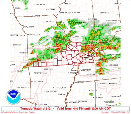
URGENT - IMMEDIATE BROADCAST REQUESTED
Tornado Watch Number 212
NWS Storm Prediction Center Norman OK
440 PM CDT Wed May 8 2024

The NWS Storm Prediction Center has issued a

* Tornado Watch for portions of
  Southern Illinois
  Western Kentucky
  Southern Missouri

* Effective this Wednesday afternoon from 440 PM until Midnight
  CDT.

* Primary threats include...
  A few tornadoes and a couple intense tornadoes likely
  Widespread large hail and scattered very large hail events to
    2.5 inches in diameter likely
  Widespread damaging winds and isolated significant gusts to 75
    mph likely

SUMMARY...Multiple rounds of severe thunderstorms will affect the
watch area through the afternoon and evening, posing a risk of large
hail and damaging winds.  A few tornadoes are also expected.

The tornado watch area is approximately along and 50 statute miles
north and south of a line from 20 miles west of Springfield MO to 40
miles north northeast of Fort Campbell KY. For a complete depiction
of the watch see the associated watch outline update (WOUS64 KWNS
WOU2).

PRECAUTIONARY/PREPAREDNESS ACTIONS...

REMEMBER...A Tornado Watch means conditions are favorable for
tornadoes and severe thunderstorms in and close to the watch
area. Persons in these areas should be on the lookout for
threatening weather conditions and listen for later statements
and possible warnings.

&&

OTHER WATCH INFORMATION...CONTINUE...WW 204...WW 205...WW
206...WW 207...WW 208...WW 209...WW 210...WW 211...

AVIATION...Tornadoes and a few severe thunderstorms with hail
surface and aloft to 2.5 inches. Extreme turbulence and surface wind
gusts to 65 knots. A few cumulonimbi with maximum tops to 500. Mean
storm motion vector 26035.

...Hart
Read morehttps://www.spc.noaa.gov/products/watch/ww0212.html
0
2
Read More
|
SPC Severe Thunderstorm Watch 207 Status Reports
Webmaster
Yesterday at 09:38 PM
SPC Severe Thunderstorm Watch 207 Status ReportsWW 0207 Status Updates 
STATUS REPORT ON WW 207

SEVERE WEATHER THREAT CONTINUES RIGHT OF A LINE FROM 30 ESE SPA
TO 25 S CLT TO 20 ESE CLT TO 30 SW GSO.

..BENTLEY..05/08/24

ATTN...WFO...RAH...ILM...GSP...MHX...CAE...


STATUS REPORT FOR WS 207

SEVERE WEATHER THREAT CONTINUES FOR THE FOLLOWING AREAS

NCC007-017-025-051-061-085-093-105-123-125-153-155-159-163-165-
167-179-082240-

NC
.    NORTH CAROLINA COUNTIES INCLUDED ARE

ANSON                BLADEN              CABARRUS
CUMBERLAND           DUPLIN              HARNETT
HOKE                 LEE                 MONTGOMERY
MOORE                RICHMOND            ROBESON
ROWAN                SAMPSON             SCOTLAND
STANLY               UNION


SCC023-025-031-033-039-041-055-057-059-061-067-069-071-087-
082240-

SC
.    SOUTH CAROLINA COUNTIES INCLUDED ARE

CHESTER              CHESTERFIELD        DARLINGTON
DILLON               FAIRFIELD           FLORENCE
KERSHAW              LANCASTER           LAURENS
LEE                  MARION              MARLBORO
NEWBERRY             UNION
Read morehttps://www.spc.noaa.gov/products/watch/ws0207.html
0
2
Read More
|
SPC Severe Thunderstorm Watch 207
Webmaster
Yesterday at 09:38 PM
SPC Severe Thunderstorm Watch 207WW 207 SEVERE TSTM NC SC 081905Z - 090200Z
URGENT - IMMEDIATE BROADCAST REQUESTED
Severe Thunderstorm Watch Number 207
NWS Storm Prediction Center Norman OK
305 PM EDT Wed May 8 2024

The NWS Storm Prediction Center has issued a

* Severe Thunderstorm Watch for portions of
  South-Central North Carolina
  Central South Carolina

* Effective this Wednesday afternoon and evening from 305 PM
  until 1000 PM EDT.

* Primary threats include...
  Scattered damaging wind gusts to 70 mph likely
  Scattered large hail and isolated very large hail events to 2
    inches in diameter possible

SUMMARY...A cluster of strong to severe thunderstorms is expected to
move into the Watch area from the west this afternoon into the
evening.  Severe gusts and associated wind damage and large hail
will be the primary severe hazards.

The severe thunderstorm watch area is approximately along and 55
statute miles north and south of a line from 20 miles south
southwest of Charlotte NC to 45 miles southeast of Fayetteville NC.
For a complete depiction of the watch see the associated watch
outline update (WOUS64 KWNS WOU7).

PRECAUTIONARY/PREPAREDNESS ACTIONS...

REMEMBER...A Severe Thunderstorm Watch means conditions are
favorable for severe thunderstorms in and close to the watch area.
Persons in these areas should be on the lookout for threatening
weather conditions and listen for later statements and possible
warnings. Severe thunderstorms can and occasionally do produce
tornadoes.

&&

OTHER WATCH INFORMATION...CONTINUE...WW 203...WW 204...WW
205...WW 206...

AVIATION...A few severe thunderstorms with hail surface and aloft to
2 inches. Extreme turbulence and surface wind gusts to 60 knots. A
few cumulonimbi with maximum tops to 500. Mean storm motion vector
26030.

...Smith
Read morehttps://www.spc.noaa.gov/products/watch/ww0207.html
0
2
Read More
|
|
Forums60
Topics685,727
Posts720,338
Members2,957
| |
Most Online3,142
Jan 16th, 2023
|
|
|
|
|
Copyright 1996 - 2023 by David Cottle. Designed by David Bate Jr. All Rights Reserved.
By using this forum, the user agrees not to transfer any data or technical information received under the agreement, to any other entity without the express approval of the AUS-CITY Forum Admins and/or authors of individual posts (Forum Admins and DoD/USSPACECOM for the analysis of satellite tracking data).
Two-line elements (TLE) and all other satellite data presented and distributed via this forum and e-mail lists of AUS-CITY are distributed with permission from DoD/USSTRATCOM.


Reprise Hosting

|

|


 - Click image for larger picture.")


