|
0 members (),
339
guests, and
24
robots. |
|
Key:
Admin,
Global Mod,
Mod
|
|
S |
M |
T |
W |
T |
F |
S |
|
|
|
|
1
|
2
|
3
|
4
|
|
5
|
6
|
7
|
8
|
9
|
10
|
11
|
|
12
|
13
|
14
|
15
|
16
|
17
|
18
|
|
19
|
20
|
21
|
22
|
23
|
24
|
25
|
|
26
|
27
|
28
|
29
|
30
|
31
|
|
|
There are no members with birthdays on this day. |

#714958
Thu 07 Mar 2024 09:25:PM
|
Joined: Feb 2001
Posts: 381,903
Launch Director
|
OP

Launch Director
Joined: Feb 2001
Posts: 381,903 |
SPC Severe Thunderstorm Watch 31WW 31 SEVERE TSTM OK TX 072100Z - 080400Z 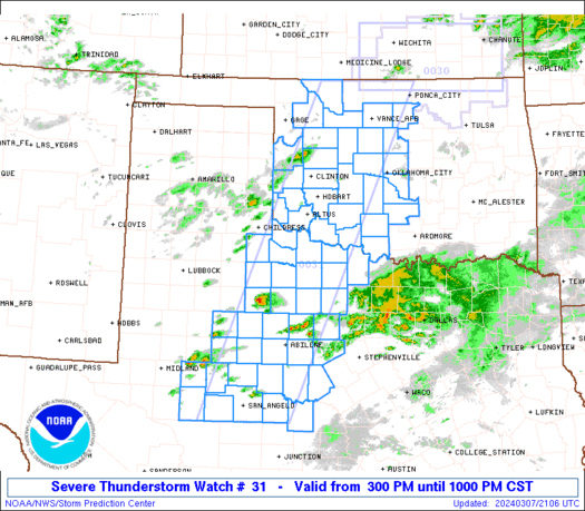
URGENT - IMMEDIATE BROADCAST REQUESTED
Severe Thunderstorm Watch Number 31
NWS Storm Prediction Center Norman OK
300 PM CST Thu Mar 7 2024

The NWS Storm Prediction Center has issued a

* Severe Thunderstorm Watch for portions of
  Western Oklahoma
  West-central and western North Texas

* Effective this Thursday afternoon and evening from 300 PM until
  1000 PM CST.

* Primary threats include...
  Scattered large hail likely with isolated very large hail events
    to 2.5 inches in diameter possible
  Scattered damaging wind gusts to 70 mph possible
  A tornado or two possible

SUMMARY...Thunderstorms are slowly intensifying in vicinity of a
dryline over western Oklahoma and west Texas.  This activity will
track eastward through the afternoon and early evening, posing a
risk of large hail and damaging winds.

The severe thunderstorm watch area is approximately along and 55
statute miles east and west of a line from 20 miles south of San
Angelo TX to 40 miles east northeast of Alva OK. For a complete
depiction of the watch see the associated watch outline update
(WOUS64 KWNS WOU1).

PRECAUTIONARY/PREPAREDNESS ACTIONS...

REMEMBER...A Severe Thunderstorm Watch means conditions are
favorable for severe thunderstorms in and close to the watch area.
Persons in these areas should be on the lookout for threatening
weather conditions and listen for later statements and possible
warnings. Severe thunderstorms can and occasionally do produce
tornadoes.

&&

OTHER WATCH INFORMATION...CONTINUE...WW 30...

AVIATION...A few severe thunderstorms with hail surface and aloft to
2.5 inches. Extreme turbulence and surface wind gusts to 60 knots. A
few cumulonimbi with maximum tops to 450. Mean storm motion vector
26030.

...Hart
Read morehttps://www.spc.noaa.gov/products/watch/ww0031.html
|
|


CMS The Best Conveyancing solicitors conveyancing quotes throughout the UK
For any webhosting enquiries please email webmaster@aus-city.com
|
|
Forums60
Topics686,801
Posts721,412
Members2,957
| |
Most Online3,142
Jan 16th, 2023
|
|
|


 - Click image for larger picture.")


