|
0 members (),
587
guests, and
33
robots. |
|
Key:
Admin,
Global Mod,
Mod
|
|
S |
M |
T |
W |
T |
F |
S |
|
|
|
|
1
|
2
|
3
|
4
|
|
5
|
6
|
7
|
8
|
9
|
10
|
11
|
|
12
|
13
|
14
|
15
|
16
|
17
|
18
|
|
19
|
20
|
21
|
22
|
23
|
24
|
25
|
|
26
|
27
|
28
|
29
|
30
|
31
|
|
|
There are no members with birthdays on this day. |

#718426
Tue 09 Apr 2024 04:59:AM
|
Joined: Feb 2001
Posts: 381,903
Launch Director
|
OP

Launch Director
Joined: Feb 2001
Posts: 381,903 |
SPC MD 391MD 0391 CONCERNING SEVERE THUNDERSTORM WATCH 93... FOR PARTS OF NORTH TX 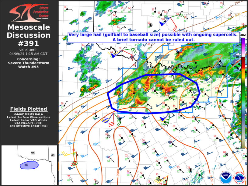
Mesoscale Discussion 0391
NWS Storm Prediction Center Norman OK
1149 PM CDT Mon Apr 08 2024

Areas affected...Parts of north TX

Concerning...Severe Thunderstorm Watch 93...

Valid 090449Z - 090615Z

The severe weather threat for Severe Thunderstorm Watch 93
continues.

SUMMARY...Very large hail (golfball to baseball size) remains
possible with an ongoing supercell cluster. A brief tornado cannot
be ruled out.

DISCUSSION...Several supercells are ongoing at 0445 UTC to the
west-northwest of the Metroplex, with multiple cells having produced
golfball or larger sized hail (up to 3 inches in diameter) within
the last hour. While some cell interactions/mergers have been noted
with the northernmost cells, the two right-moving supercells ongoing
west of Mineral Wells and north of Fort Worth may be able to move
east-northeastward with minimal interference in the short term.

MLCAPE of around 2000 J/kg and effective shear of 45-55 kt will
continue to support supercell potential into the early overnight
hours, with very large hail (potentially 2-3 inches in diameter with
the strongest cells) as the primary threat, along with some risk for
localized severe gusts. Also, low-level flow has substantially
increased over the last 1-2 hours on the KFWS VWP, with 0-1 km SRH
increasing above 150 m2/s2. This could support a brief tornado
threat with the strongest right-moving cells, though relatively cool
near-surface conditions may mitigate this threat to some extent.

..Dean.. 04/09/2024

...Please see www.spc.noaa.gov for graphic product...

ATTN...WFO...FWD...OUN...SJT...

LAT...LON   33359899 33639814 33679694 33399637 33109626 32919638
            32709657 32609701 32549747 32529802 32539848 32579908
            32679931 32979941 33099945 33359899
Read morehttps://www.spc.noaa.gov/products/md/md0391.html
|
|


CMS The Best Conveyancing solicitors conveyancing quotes throughout the UK
For any webhosting enquiries please email webmaster@aus-city.com
|
|
Forums60
Topics684,854
Posts719,465
Members2,957
| |
Most Online3,142
Jan 16th, 2023
|
|
|


 - Click image for larger picture.")


