|
|
|
0 members (),
919
guests, and
23
robots. |
|
Key:
Admin,
Global Mod,
Mod
|
|
S |
M |
T |
W |
T |
F |
S |
|
|
1
|
2
|
3
|
4
|
5
|
6
|
|
7
|
8
|
9
|
10
|
11
|
12
|
13
|
|
14
|
15
|
16
|
17
|
18
|
19
|
20
|
|
21
|
22
|
23
|
24
|
25
|
26
|
27
|
|
28
|
29
|
30
|
|
|
|
|
|
There are no members with birthdays on this day. |

#719356
Tue 16 Apr 2024 12:00:AM
|
Joined: Feb 2001
Posts: 381,903
Launch Director
|
OP

Launch Director
Joined: Feb 2001
Posts: 381,903 |
SPC MD 446MD 0446 CONCERNING SEVERE THUNDERSTORM WATCH 109... FOR EASTERN MID ATLANTIC 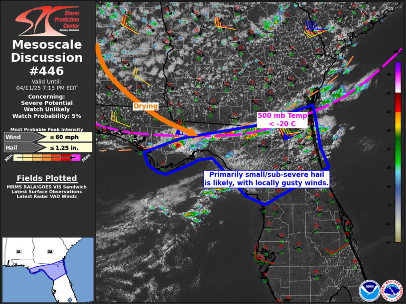
Mesoscale Discussion 0446
NWS Storm Prediction Center Norman OK
0557 PM CDT Mon Apr 15 2024

Areas affected...eastern Mid Atlantic

Concerning...Severe Thunderstorm Watch 109...

Valid 152257Z - 160030Z

The severe weather threat for Severe Thunderstorm Watch 109
continues.

SUMMARY...The risk for damaging gusts and hail continues. Ongoing
clusters of storms will gradually shift southeast through the
evening.

DISCUSSION...As of 2355 UTC, regional radar showed multiple clusters
of storms, and occasional supercell structures, ongoing across parts
of central and eastern VA. The environment ahead of these clusters
remains broadly favorable for damaging winds and hail given 500-1000
J/kg of MLCAPE and 35-40 kt of effective shear. Recent hi-res
guidance suggest the ongoing clusters will continue to track
east/southeast this with gradual upscale growth. Damaging gusts
appear to be the most likely hazard with storm interactions and
relatively modest boundary-layer moisture present over parts of
eastern VA. However, severe hail should still remain possible,
especially with any supercellular elements, given robust mid-level
lapse rates of 7-8 C/km. The strongest activity should remain
focused over the southern half of the Watch area, though more
isolated development will remain possible on trailing outflow and
over the higher terrain in western VA/WV through the next few hours.

..Lyons.. 04/15/2024

...Please see www.spc.noaa.gov for graphic product...

ATTN...WFO...AKQ...LWX...RNK...RLX...

LAT...LON   36577794 36558042 36878140 37148159 37638158 38778142
            38107857 37977791 38087685 38147618 37957582 37577537
            36857556 36587574 36427659 36537770 36577794
Read morehttps://www.spc.noaa.gov/products/md/md0446.html
|
|


CMS The Best Conveyancing solicitors conveyancing quotes throughout the UK
For any webhosting enquiries please email webmaster@aus-city.com
|
|
Forums60
Topics684,607
Posts719,217
Members2,957
| |
Most Online3,142
Jan 16th, 2023
|
|
|
|
|
Copyright 1996 - 2023 by David Cottle. Designed by David Bate Jr. All Rights Reserved.
By using this forum, the user agrees not to transfer any data or technical information received under the agreement, to any other entity without the express approval of the AUS-CITY Forum Admins and/or authors of individual posts (Forum Admins and DoD/USSPACECOM for the analysis of satellite tracking data).
Two-line elements (TLE) and all other satellite data presented and distributed via this forum and e-mail lists of AUS-CITY are distributed with permission from DoD/USSTRATCOM.

Reprise Hosting

|

|


 - Click image for larger picture.")


