|
|
|
0 members (),
708
guests, and
31
robots. |
|
Key:
Admin,
Global Mod,
Mod
|
|
S |
M |
T |
W |
T |
F |
S |
|
|
|
|
1
|
2
|
3
|
4
|
|
5
|
6
|
7
|
8
|
9
|
10
|
11
|
|
12
|
13
|
14
|
15
|
16
|
17
|
18
|
|
19
|
20
|
21
|
22
|
23
|
24
|
25
|
|
26
|
27
|
28
|
29
|
30
|
31
|
|
|
There are no members with birthdays on this day. |

#718427
Tue 09 Apr 2024 04:59:AM
|
Joined: Feb 2001
Posts: 381,903
Launch Director
|
OP

Launch Director
Joined: Feb 2001
Posts: 381,903 |
SPC MD 390MD 0390 CONCERNING SEVERE POTENTIAL...WATCH POSSIBLE FOR TX PERMIAN BASIN VICINITY 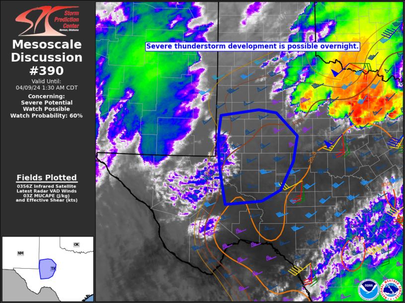
Mesoscale Discussion 0390
NWS Storm Prediction Center Norman OK
1059 PM CDT Mon Apr 08 2024

Areas affected...TX Permian Basin vicinity

Concerning...Severe potential...Watch possible

Valid 090359Z - 090630Z

Probability of Watch Issuance...60 percent

SUMMARY...Severe thunderstorm development will be possible
overnight, with a threat of large hail.

DISCUSSION...Low-level moisture continues to stream northwestward
late this evening into portions of the TX Permian Basin region.
Meanwhile, WV and IR imagery suggests that ascent related to the
deep upper-level trough over the Southwest is beginning to
overspread the region. While timing remains uncertain, storm
development will become increasingly likely overnight, especially
near/north of a southward-moving cold front. Steep midlevel lapse
rates, MUCAPE increasing into the 1000-2000 J/kg range, and
effective shear of 40+ kts will support elevated supercell
potential, with an attendant threat of large hail in the 1.5 - 2
inch diameter range.

Severe-storm coverage remains somewhat uncertain overnight and could
remain rather isolated, but eventual watch issuance is possible
given the potential for elevated supercells.

..Dean/Hart.. 04/09/2024

...Please see www.spc.noaa.gov for graphic product...

ATTN...WFO...SJT...LUB...MAF...

LAT...LON   32360300 32700297 33040291 33200177 33110124 32510060
            31860073 31130112 30860168 30770276 31710295 32360300
Read morehttps://www.spc.noaa.gov/products/md/md0390.html
|
|


CMS The Best Conveyancing solicitors conveyancing quotes throughout the UK
For any webhosting enquiries please email webmaster@aus-city.com
|
|
Forums60
Topics684,904
Posts719,515
Members2,957
| |
Most Online3,142
Jan 16th, 2023
|
|
|
|
|
Copyright 1996 - 2023 by David Cottle. Designed by David Bate Jr. All Rights Reserved.
By using this forum, the user agrees not to transfer any data or technical information received under the agreement, to any other entity without the express approval of the AUS-CITY Forum Admins and/or authors of individual posts (Forum Admins and DoD/USSPACECOM for the analysis of satellite tracking data).
Two-line elements (TLE) and all other satellite data presented and distributed via this forum and e-mail lists of AUS-CITY are distributed with permission from DoD/USSTRATCOM.

Reprise Hosting

|

|


 - Click image for larger picture.")


